You are here: Home > Network List > CI - Caltech Regional Seismic Network Stations List
> Station TIN Tinemaha, Big Pine, CA, USA > Earthquake Result Viewer
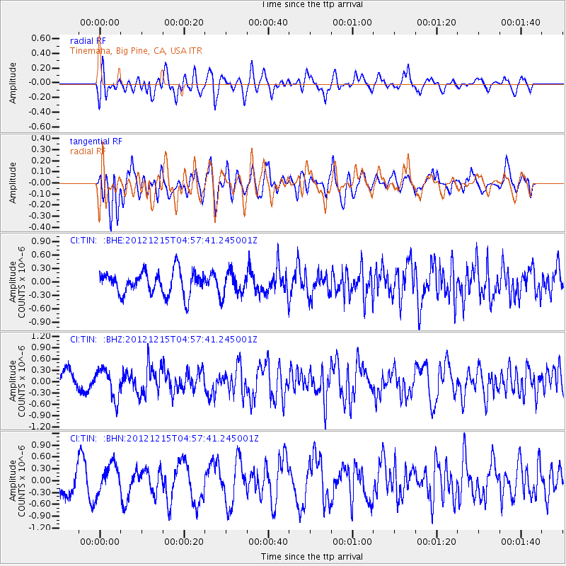
TIN Tinemaha, Big Pine, CA, USA - Earthquake Result Viewer
*The percent match for this event was below the threshold and hence no stack was calculated.
| Earthquake location: |
Near Islands, Aleutian Islands |
| Earthquake latitude/longitude: |
52.3/174.0 |
| Earthquake time(UTC): |
2012/12/15 (350) 04:49:29 GMT |
| Earthquake Depth: |
26 km |
| Earthquake Magnitude: |
5.7 MB, 5.7 MS, 6.0 MW, 5.9 MW |
| Earthquake Catalog/Contributor: |
WHDF/NEIC |
|
| Network: |
CI Caltech Regional Seismic Network |
| Station: |
TIN Tinemaha, Big Pine, CA, USA |
| Lat/Lon: |
37.05 N/118.23 W |
| Elevation: |
1197 m |
|
| Distance: |
48.7 deg |
| Az: |
80.075 deg |
| Baz: |
310.863 deg |
| Ray Param: |
$rayparam |
*The percent match for this event was below the threshold and hence was not used in the summary stack. |
|
| Radial Match: |
59.841637 % |
| Radial Bump: |
400 |
| Transverse Match: |
62.028816 % |
| Transverse Bump: |
400 |
| SOD ConfigId: |
491031 |
| Insert Time: |
2013-04-02 16:09:09.808 +0000 |
| GWidth: |
2.5 |
| Max Bumps: |
400 |
| Tol: |
0.001 |
|
Signal To Noise
| Channel | StoN | STA | LTA |
| CI:TIN: :BHZ:20121215T04:57:41.245001Z | 1.4170983 | 3.937594E-7 | 2.7786317E-7 |
| CI:TIN: :BHN:20121215T04:57:41.245001Z | 1.4899647 | 3.7136206E-7 | 2.492422E-7 |
| CI:TIN: :BHE:20121215T04:57:41.245001Z | 0.95369095 | 2.4030777E-7 | 2.519766E-7 |
| Arrivals |
| Ps | |
| PpPs | |
| PsPs/PpSs | |


