You are here: Home > Network List > IU - Global Seismograph Network (GSN - IRIS/USGS) Stations List
> Station GRFO Grafenberg, Germany > Earthquake Result Viewer
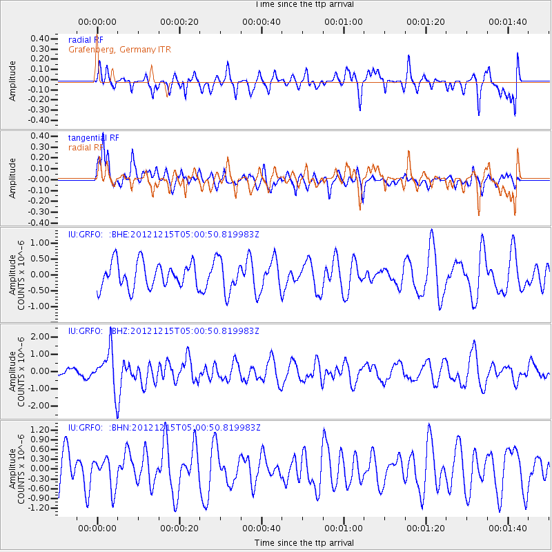
GRFO Grafenberg, Germany - Earthquake Result Viewer
*The percent match for this event was below the threshold and hence no stack was calculated.
| Earthquake location: |
Near Islands, Aleutian Islands |
| Earthquake latitude/longitude: |
52.3/174.0 |
| Earthquake time(UTC): |
2012/12/15 (350) 04:49:29 GMT |
| Earthquake Depth: |
26 km |
| Earthquake Magnitude: |
5.7 MB, 5.7 MS, 6.0 MW, 5.9 MW |
| Earthquake Catalog/Contributor: |
WHDF/NEIC |
|
| Network: |
IU Global Seismograph Network (GSN - IRIS/USGS) |
| Station: |
GRFO Grafenberg, Germany |
| Lat/Lon: |
49.69 N/11.22 E |
| Elevation: |
384 m |
|
| Distance: |
77.3 deg |
| Az: |
348.643 deg |
| Baz: |
10.734 deg |
| Ray Param: |
$rayparam |
*The percent match for this event was below the threshold and hence was not used in the summary stack. |
|
| Radial Match: |
53.92272 % |
| Radial Bump: |
400 |
| Transverse Match: |
61.61852 % |
| Transverse Bump: |
400 |
| SOD ConfigId: |
491031 |
| Insert Time: |
2013-04-02 16:11:20.443 +0000 |
| GWidth: |
2.5 |
| Max Bumps: |
400 |
| Tol: |
0.001 |
|
Signal To Noise
| Channel | StoN | STA | LTA |
| IU:GRFO: :BHZ:20121215T05:00:50.819983Z | 4.8574796 | 1.2102983E-6 | 2.491618E-7 |
| IU:GRFO: :BHN:20121215T05:00:50.819983Z | 0.8043183 | 4.841567E-7 | 6.019467E-7 |
| IU:GRFO: :BHE:20121215T05:00:50.819983Z | 1.3434927 | 5.3264745E-7 | 3.964647E-7 |
| Arrivals |
| Ps | |
| PpPs | |
| PsPs/PpSs | |


