You are here: Home > Network List > TA - USArray Transportable Network (new EarthScope stations) Stations List
> Station R11A Troy Canyon, Currant, NV, USA > Earthquake Result Viewer
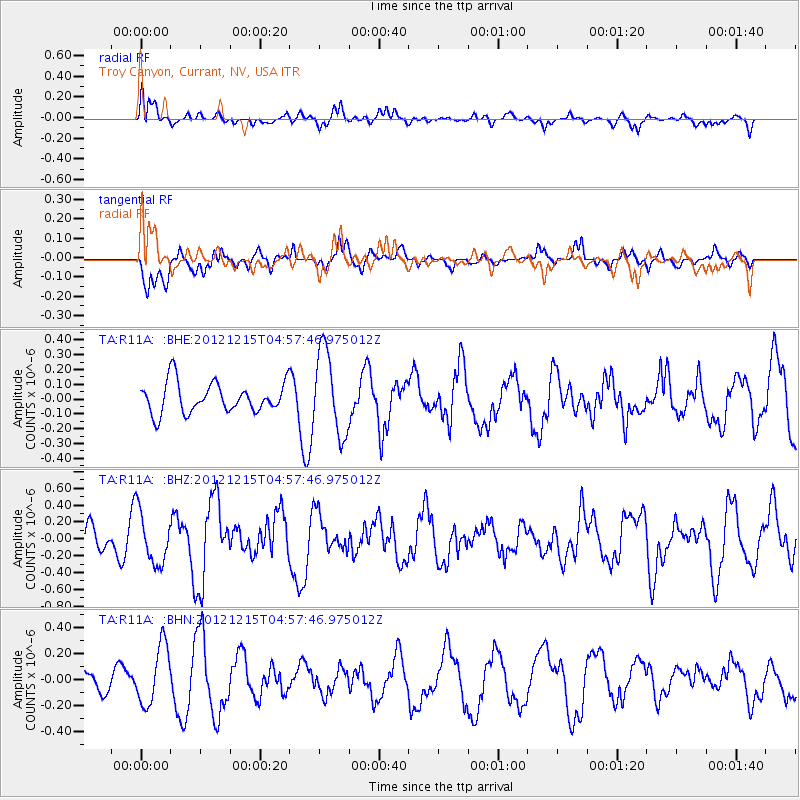
R11A Troy Canyon, Currant, NV, USA - Earthquake Result Viewer
*The percent match for this event was below the threshold and hence no stack was calculated.
| Earthquake location: |
Near Islands, Aleutian Islands |
| Earthquake latitude/longitude: |
52.3/174.0 |
| Earthquake time(UTC): |
2012/12/15 (350) 04:49:29 GMT |
| Earthquake Depth: |
26 km |
| Earthquake Magnitude: |
5.7 MB, 5.7 MS, 6.0 MW, 5.9 MW |
| Earthquake Catalog/Contributor: |
WHDF/NEIC |
|
| Network: |
TA USArray Transportable Network (new EarthScope stations) |
| Station: |
R11A Troy Canyon, Currant, NV, USA |
| Lat/Lon: |
38.35 N/115.59 W |
| Elevation: |
1756 m |
|
| Distance: |
49.5 deg |
| Az: |
76.97 deg |
| Baz: |
310.441 deg |
| Ray Param: |
$rayparam |
*The percent match for this event was below the threshold and hence was not used in the summary stack. |
|
| Radial Match: |
60.721043 % |
| Radial Bump: |
400 |
| Transverse Match: |
68.74365 % |
| Transverse Bump: |
400 |
| SOD ConfigId: |
491031 |
| Insert Time: |
2013-04-02 16:14:24.983 +0000 |
| GWidth: |
2.5 |
| Max Bumps: |
400 |
| Tol: |
0.001 |
|
Signal To Noise
| Channel | StoN | STA | LTA |
| TA:R11A: :BHZ:20121215T04:57:46.975012Z | 1.7025822 | 3.0635107E-7 | 1.799332E-7 |
| TA:R11A: :BHN:20121215T04:57:46.975012Z | 2.1628444 | 2.2830443E-7 | 1.0555749E-7 |
| TA:R11A: :BHE:20121215T04:57:46.975012Z | 2.76118 | 2.8210323E-7 | 1.0216763E-7 |
| Arrivals |
| Ps | |
| PpPs | |
| PsPs/PpSs | |


