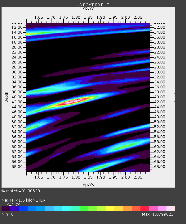
EGMT Eagleton, Montana, USA - Earthquake Result Viewer
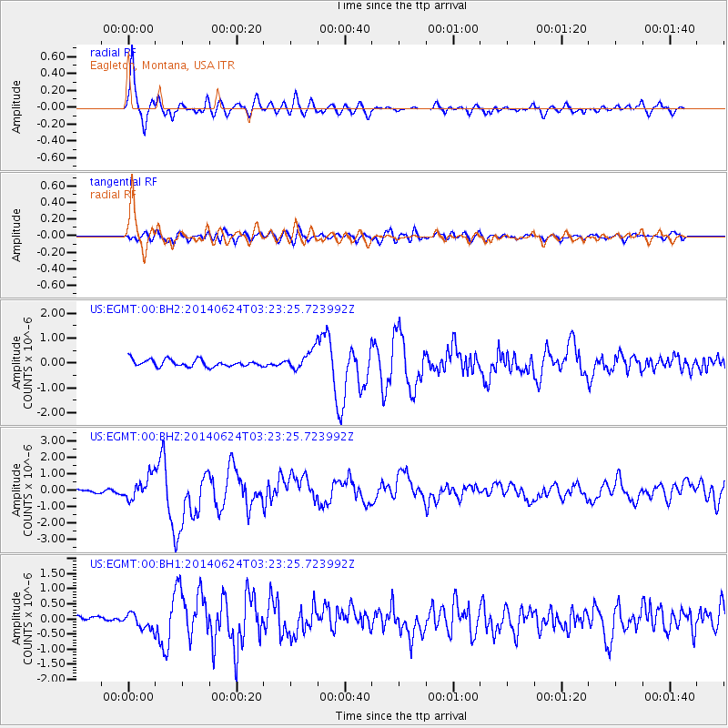
Earthquake location: Rat Islands, Aleutian Islands
Earthquake latitude/longitude: 52.3/176.7
Earthquake time(UTC): 2014/06/24 (175) 03:15:36 GMT
Earthquake Depth: 4.0 km
Earthquake Magnitude: 6.3 MWB, 5.7 ML, 6.4 MWC, 6.6 MI
Earthquake Catalog/Contributor: NEIC PDE/NEIC COMCAT
Network: US United States National Seismic Network
Station: EGMT Eagleton, Montana, USA
Lat/Lon: 48.02 N/109.75 W
Elevation: 1055 m
Distance: 45.4 deg
Az: 64.61 deg
Baz: 304.176 deg
Ray Param: 0.0712896
Estimated Moho Depth: 41.5 km
Estimated Crust Vp/Vs: 1.79
Assumed Crust Vp: 6.438 km/s
Estimated Crust Vs: 3.596 km/s
Estimated Crust Poisson's Ratio: 0.27
Radial Match: 91.30529 %
Radial Bump: 400
Transverse Match: 72.8323 %
Transverse Bump: 400
SOD ConfigId: 3390531
Insert Time: 2019-04-12 12:25:23.494 +0000
GWidth: 2.5
Max Bumps: 400
Tol: 0.001

Signal To Noise

ChannelStoNSTALTA
US:EGMT:00:BHZ:20140624T03:23:25.723992Z4.7428096.8855184E-71.4517806E-7
US:EGMT:00:BH1:20140624T03:23:25.723992Z1.91657232.5510047E-71.3310245E-7
US:EGMT:00:BH2:20140624T03:23:25.723992Z2.67947053.672522E-71.3706148E-7
Arrivals
Ps5.4 SECOND
PpPs17 SECOND
PsPs/PpSs22 SECOND