You are here: Home > Network List > TA - USArray Transportable Network (new EarthScope stations) Stations List
> Station R47A Wooly Knot Farm, English, IN, USA > Earthquake Result Viewer
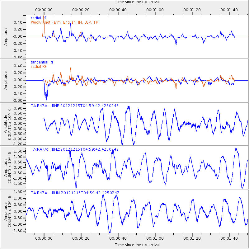
R47A Wooly Knot Farm, English, IN, USA - Earthquake Result Viewer
*The percent match for this event was below the threshold and hence no stack was calculated.
| Earthquake location: |
Near Islands, Aleutian Islands |
| Earthquake latitude/longitude: |
52.3/174.0 |
| Earthquake time(UTC): |
2012/12/15 (350) 04:49:29 GMT |
| Earthquake Depth: |
26 km |
| Earthquake Magnitude: |
5.7 MB, 5.7 MS, 6.0 MW, 5.9 MW |
| Earthquake Catalog/Contributor: |
WHDF/NEIC |
|
| Network: |
TA USArray Transportable Network (new EarthScope stations) |
| Station: |
R47A Wooly Knot Farm, English, IN, USA |
| Lat/Lon: |
38.30 N/86.53 W |
| Elevation: |
181 m |
|
| Distance: |
65.9 deg |
| Az: |
58.204 deg |
| Baz: |
318.435 deg |
| Ray Param: |
$rayparam |
*The percent match for this event was below the threshold and hence was not used in the summary stack. |
|
| Radial Match: |
65.58866 % |
| Radial Bump: |
400 |
| Transverse Match: |
85.235794 % |
| Transverse Bump: |
400 |
| SOD ConfigId: |
491031 |
| Insert Time: |
2013-04-02 16:17:57.906 +0000 |
| GWidth: |
2.5 |
| Max Bumps: |
400 |
| Tol: |
0.001 |
|
Signal To Noise
| Channel | StoN | STA | LTA |
| TA:R47A: :BHZ:20121215T04:59:42.425024Z | 0.908405 | 5.948613E-7 | 6.548416E-7 |
| TA:R47A: :BHN:20121215T04:59:42.425024Z | 0.43223152 | 2.2896124E-7 | 5.29719E-7 |
| TA:R47A: :BHE:20121215T04:59:42.425024Z | 2.4863448 | 6.650097E-7 | 2.674648E-7 |
| Arrivals |
| Ps | |
| PpPs | |
| PsPs/PpSs | |


