You are here: Home > Network List > TA - USArray Transportable Network (new EarthScope stations) Stations List
> Station X48A Hartselle, AL, USA > Earthquake Result Viewer
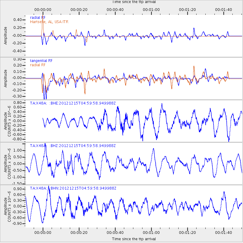
X48A Hartselle, AL, USA - Earthquake Result Viewer
*The percent match for this event was below the threshold and hence no stack was calculated.
| Earthquake location: |
Near Islands, Aleutian Islands |
| Earthquake latitude/longitude: |
52.3/174.0 |
| Earthquake time(UTC): |
2012/12/15 (350) 04:49:29 GMT |
| Earthquake Depth: |
26 km |
| Earthquake Magnitude: |
5.7 MB, 5.7 MS, 6.0 MW, 5.9 MW |
| Earthquake Catalog/Contributor: |
WHDF/NEIC |
|
| Network: |
TA USArray Transportable Network (new EarthScope stations) |
| Station: |
X48A Hartselle, AL, USA |
| Lat/Lon: |
34.45 N/87.05 W |
| Elevation: |
180 m |
|
| Distance: |
68.6 deg |
| Az: |
61.281 deg |
| Baz: |
319.319 deg |
| Ray Param: |
$rayparam |
*The percent match for this event was below the threshold and hence was not used in the summary stack. |
|
| Radial Match: |
56.741432 % |
| Radial Bump: |
400 |
| Transverse Match: |
83.20677 % |
| Transverse Bump: |
400 |
| SOD ConfigId: |
491031 |
| Insert Time: |
2013-04-02 16:18:19.172 +0000 |
| GWidth: |
2.5 |
| Max Bumps: |
400 |
| Tol: |
0.001 |
|
Signal To Noise
| Channel | StoN | STA | LTA |
| TA:X48A: :BHZ:20121215T04:59:58.949988Z | 1.8519307 | 6.265066E-7 | 3.3829917E-7 |
| TA:X48A: :BHN:20121215T04:59:58.949988Z | 1.7167913 | 6.1716366E-7 | 3.5948673E-7 |
| TA:X48A: :BHE:20121215T04:59:58.949988Z | 1.6194103 | 2.4585333E-7 | 1.5181658E-7 |
| Arrivals |
| Ps | |
| PpPs | |
| PsPs/PpSs | |


