You are here: Home > Network List > TA - USArray Transportable Network (new EarthScope stations) Stations List
> Station Q48A North Vernon, IN, USA > Earthquake Result Viewer
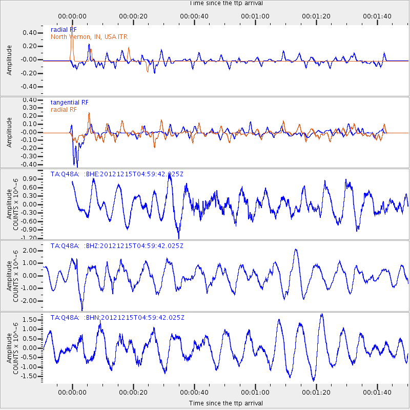
Q48A North Vernon, IN, USA - Earthquake Result Viewer
*The percent match for this event was below the threshold and hence no stack was calculated.
| Earthquake location: |
Near Islands, Aleutian Islands |
| Earthquake latitude/longitude: |
52.3/174.0 |
| Earthquake time(UTC): |
2012/12/15 (350) 04:49:29 GMT |
| Earthquake Depth: |
26 km |
| Earthquake Magnitude: |
5.7 MB, 5.7 MS, 6.0 MW, 5.9 MW |
| Earthquake Catalog/Contributor: |
WHDF/NEIC |
|
| Network: |
TA USArray Transportable Network (new EarthScope stations) |
| Station: |
Q48A North Vernon, IN, USA |
| Lat/Lon: |
38.93 N/85.73 W |
| Elevation: |
185 m |
|
| Distance: |
65.9 deg |
| Az: |
57.233 deg |
| Baz: |
318.533 deg |
| Ray Param: |
$rayparam |
*The percent match for this event was below the threshold and hence was not used in the summary stack. |
|
| Radial Match: |
68.81598 % |
| Radial Bump: |
400 |
| Transverse Match: |
83.20683 % |
| Transverse Bump: |
389 |
| SOD ConfigId: |
491031 |
| Insert Time: |
2013-04-02 16:19:49.860 +0000 |
| GWidth: |
2.5 |
| Max Bumps: |
400 |
| Tol: |
0.001 |
|
Signal To Noise
| Channel | StoN | STA | LTA |
| TA:Q48A: :BHZ:20121215T04:59:42.025Z | 1.687015 | 1.2818596E-6 | 7.598388E-7 |
| TA:Q48A: :BHN:20121215T04:59:42.025Z | 0.7223828 | 3.672974E-7 | 5.084526E-7 |
| TA:Q48A: :BHE:20121215T04:59:42.025Z | 1.593934 | 6.440022E-7 | 4.0403316E-7 |
| Arrivals |
| Ps | |
| PpPs | |
| PsPs/PpSs | |


