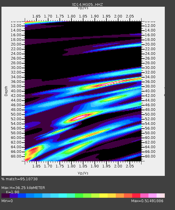
MG05 "Mount St Helens, WA" - Earthquake Result Viewer

Earthquake location: Rat Islands, Aleutian Islands
Earthquake latitude/longitude: 52.3/176.7
Earthquake time(UTC): 2014/06/24 (175) 03:15:36 GMT
Earthquake Depth: 4.0 km
Earthquake Magnitude: 6.3 MWB, 5.7 ML, 6.4 MWC, 6.6 MI
Earthquake Catalog/Contributor: NEIC PDE/NEIC COMCAT
Network: XD Illuminating the architecture of the greater Mount St. Helens magmatic systems f
Station: MG05 "Mount St Helens, WA"
Lat/Lon: 46.31 N/122.34 W
Elevation: 1283 m
Distance: 39.2 deg
Az: 73.673 deg
Baz: 301.676 deg
Ray Param: 0.07516209
Estimated Moho Depth: 36.25 km
Estimated Crust Vp/Vs: 1.98
Assumed Crust Vp: 6.566 km/s
Estimated Crust Vs: 3.316 km/s
Estimated Crust Poisson's Ratio: 0.33
Radial Match: 95.18738 %
Radial Bump: 220
Transverse Match: 66.37084 %
Transverse Bump: 400
SOD ConfigId: 3390531
Insert Time: 2019-04-12 12:26:08.421 +0000
GWidth: 2.5
Max Bumps: 400
Tol: 0.001

Signal To Noise

ChannelStoNSTALTA
XD:MG05: :HHZ:20140624T03:22:34.295006Z2.33132843.931814E-71.6865124E-7
XD:MG05: :HHN:20140624T03:22:34.295006Z1.54493461.3757476E-78.904892E-8
XD:MG05: :HHE:20140624T03:22:34.295006Z4.05782462.8146704E-76.936403E-8
Arrivals
Ps5.8 SECOND
PpPs15 SECOND
PsPs/PpSs21 SECOND