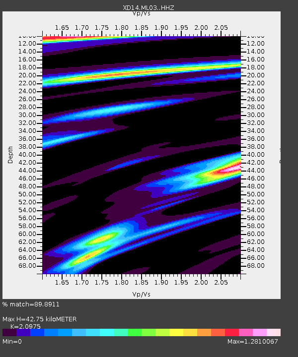
ML03 "Mount St Helens, WA" - Earthquake Result Viewer

Earthquake location: Rat Islands, Aleutian Islands
Earthquake latitude/longitude: 52.3/176.7
Earthquake time(UTC): 2014/06/24 (175) 03:15:36 GMT
Earthquake Depth: 4.0 km
Earthquake Magnitude: 6.3 MWB, 5.7 ML, 6.4 MWC, 6.6 MI
Earthquake Catalog/Contributor: NEIC PDE/NEIC COMCAT
Network: XD Illuminating the architecture of the greater Mount St. Helens magmatic systems f
Station: ML03 "Mount St Helens, WA"
Lat/Lon: 46.06 N/122.52 W
Elevation: 356 m
Distance: 39.2 deg
Az: 74.102 deg
Baz: 301.883 deg
Ray Param: 0.0751474
Estimated Moho Depth: 42.75 km
Estimated Crust Vp/Vs: 2.10
Assumed Crust Vp: 6.566 km/s
Estimated Crust Vs: 3.13 km/s
Estimated Crust Poisson's Ratio: 0.35
Radial Match: 89.8911 %
Radial Bump: 361
Transverse Match: 87.703865 %
Transverse Bump: 400
SOD ConfigId: 3390531
Insert Time: 2019-04-12 12:26:15.433 +0000
GWidth: 2.5
Max Bumps: 400
Tol: 0.001

Signal To Noise

ChannelStoNSTALTA
XD:ML03: :HHZ:20140624T03:22:34.490013Z2.88202574.3755725E-71.518228E-7
XD:ML03: :HHN:20140624T03:22:34.490013Z0.879435668.7375E-89.935349E-8
XD:ML03: :HHE:20140624T03:22:34.490013Z1.46174162.7753404E-71.8986532E-7
Arrivals
Ps7.6 SECOND
PpPs19 SECOND
PsPs/PpSs27 SECOND