You are here: Home > Network List > AZ - ANZA Regional Network Stations List
> Station LVA2 AZ.LVA2 > Earthquake Result Viewer
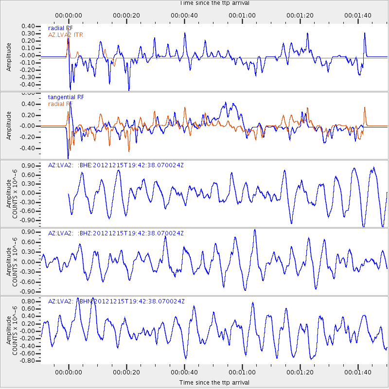
LVA2 AZ.LVA2 - Earthquake Result Viewer
*The percent match for this event was below the threshold and hence no stack was calculated.
| Earthquake location: |
New Ireland Region, P.N.G. |
| Earthquake latitude/longitude: |
-4.6/153.0 |
| Earthquake time(UTC): |
2012/12/15 (350) 19:30:02 GMT |
| Earthquake Depth: |
52 km |
| Earthquake Magnitude: |
5.9 MB, 6.1 MW, 6.1 MW |
| Earthquake Catalog/Contributor: |
WHDF/NEIC |
|
| Network: |
AZ ANZA Regional Network |
| Station: |
LVA2 AZ.LVA2 |
| Lat/Lon: |
33.35 N/116.56 W |
| Elevation: |
1435 m |
|
| Distance: |
92.9 deg |
| Az: |
56.933 deg |
| Baz: |
266.376 deg |
| Ray Param: |
$rayparam |
*The percent match for this event was below the threshold and hence was not used in the summary stack. |
|
| Radial Match: |
66.978516 % |
| Radial Bump: |
400 |
| Transverse Match: |
34.278282 % |
| Transverse Bump: |
400 |
| SOD ConfigId: |
491031 |
| Insert Time: |
2013-04-02 16:25:30.691 +0000 |
| GWidth: |
2.5 |
| Max Bumps: |
400 |
| Tol: |
0.001 |
|
Signal To Noise
| Channel | StoN | STA | LTA |
| AZ:LVA2: :BHZ:20121215T19:42:38.070024Z | 1.2495236 | 2.776517E-7 | 2.2220605E-7 |
| AZ:LVA2: :BHN:20121215T19:42:38.070024Z | 1.7915025 | 9.313757E-7 | 5.1988525E-7 |
| AZ:LVA2: :BHE:20121215T19:42:38.070024Z | 0.7323007 | 3.0001743E-7 | 4.0969158E-7 |
| Arrivals |
| Ps | |
| PpPs | |
| PsPs/PpSs | |


