You are here: Home > Network List > AZ - ANZA Regional Network Stations List
> Station SOL AZ.SOL > Earthquake Result Viewer
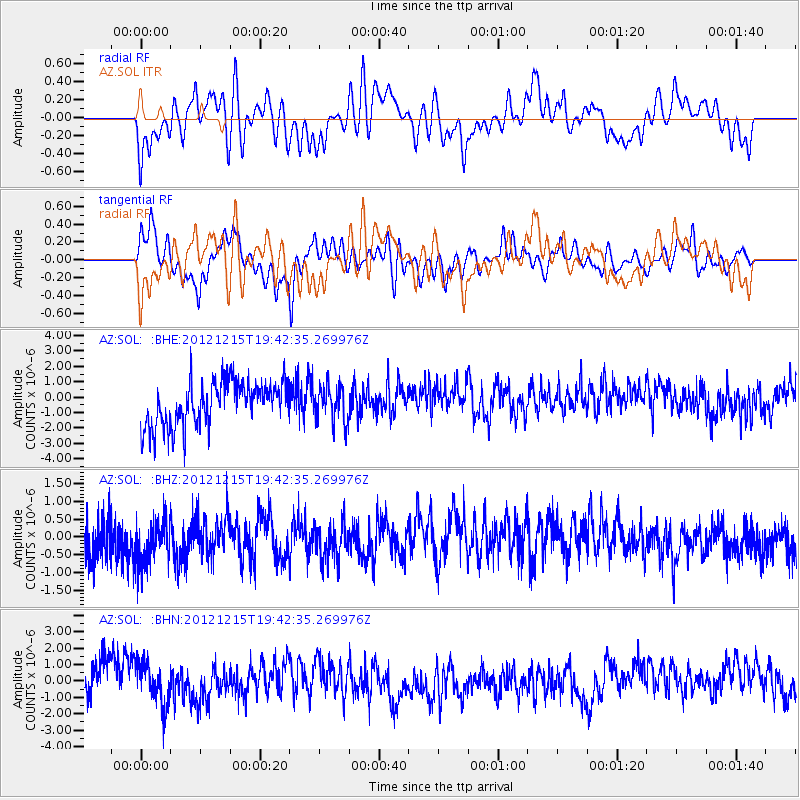
SOL AZ.SOL - Earthquake Result Viewer
*The percent match for this event was below the threshold and hence no stack was calculated.
| Earthquake location: |
New Ireland Region, P.N.G. |
| Earthquake latitude/longitude: |
-4.6/153.0 |
| Earthquake time(UTC): |
2012/12/15 (350) 19:30:02 GMT |
| Earthquake Depth: |
52 km |
| Earthquake Magnitude: |
5.9 MB, 6.1 MW, 6.1 MW |
| Earthquake Catalog/Contributor: |
WHDF/NEIC |
|
| Network: |
AZ ANZA Regional Network |
| Station: |
SOL AZ.SOL |
| Lat/Lon: |
32.84 N/117.25 W |
| Elevation: |
245 m |
|
| Distance: |
92.3 deg |
| Az: |
57.403 deg |
| Baz: |
265.982 deg |
| Ray Param: |
$rayparam |
*The percent match for this event was below the threshold and hence was not used in the summary stack. |
|
| Radial Match: |
52.210487 % |
| Radial Bump: |
400 |
| Transverse Match: |
50.731487 % |
| Transverse Bump: |
400 |
| SOD ConfigId: |
491031 |
| Insert Time: |
2013-04-02 16:25:30.729 +0000 |
| GWidth: |
2.5 |
| Max Bumps: |
400 |
| Tol: |
0.001 |
|
Signal To Noise
| Channel | StoN | STA | LTA |
| AZ:SOL: :BHZ:20121215T19:42:35.269976Z | 1.314333 | 7.2542406E-7 | 5.519332E-7 |
| AZ:SOL: :BHN:20121215T19:42:35.269976Z | 1.3345714 | 1.2579353E-6 | 9.4257626E-7 |
| AZ:SOL: :BHE:20121215T19:42:35.269976Z | 0.7619636 | 1.0912584E-6 | 1.432166E-6 |
| Arrivals |
| Ps | |
| PpPs | |
| PsPs/PpSs | |


