You are here: Home > Network List > IW - Intermountain West Stations List
> Station PLID Pearl Lake, Idaho, USA > Earthquake Result Viewer
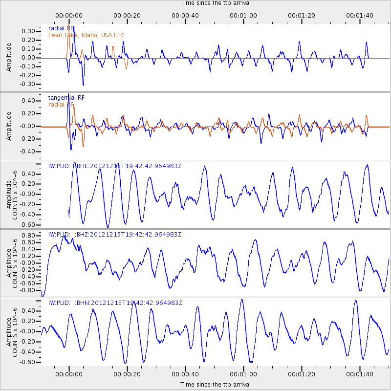
PLID Pearl Lake, Idaho, USA - Earthquake Result Viewer
*The percent match for this event was below the threshold and hence no stack was calculated.
| Earthquake location: |
New Ireland Region, P.N.G. |
| Earthquake latitude/longitude: |
-4.6/153.0 |
| Earthquake time(UTC): |
2012/12/15 (350) 19:30:02 GMT |
| Earthquake Depth: |
52 km |
| Earthquake Magnitude: |
5.9 MB, 6.1 MW, 6.1 MW |
| Earthquake Catalog/Contributor: |
WHDF/NEIC |
|
| Network: |
IW Intermountain West |
| Station: |
PLID Pearl Lake, Idaho, USA |
| Lat/Lon: |
45.09 N/116.00 W |
| Elevation: |
2164 m |
|
| Distance: |
93.9 deg |
| Az: |
45.233 deg |
| Baz: |
267.429 deg |
| Ray Param: |
$rayparam |
*The percent match for this event was below the threshold and hence was not used in the summary stack. |
|
| Radial Match: |
57.58469 % |
| Radial Bump: |
319 |
| Transverse Match: |
56.838337 % |
| Transverse Bump: |
400 |
| SOD ConfigId: |
491031 |
| Insert Time: |
2013-04-02 16:27:30.065 +0000 |
| GWidth: |
2.5 |
| Max Bumps: |
400 |
| Tol: |
0.001 |
|
Signal To Noise
| Channel | StoN | STA | LTA |
| IW:PLID: :BHZ:20121215T19:42:42.964983Z | 2.0276265 | 7.4702893E-7 | 3.684253E-7 |
| IW:PLID: :BHN:20121215T19:42:42.964983Z | 0.7922256 | 2.4342052E-7 | 3.0726164E-7 |
| IW:PLID: :BHE:20121215T19:42:42.964983Z | 0.28579077 | 1.07639764E-7 | 3.7663835E-7 |
| Arrivals |
| Ps | |
| PpPs | |
| PsPs/PpSs | |


