You are here: Home > Network List > G - GEOSCOPE Stations List
> Station DZM Dzumac, New Caledonia > Earthquake Result Viewer
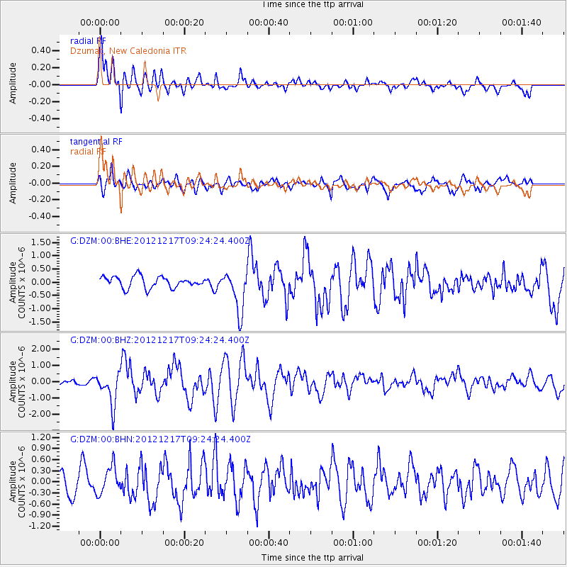
DZM Dzumac, New Caledonia - Earthquake Result Viewer
*The percent match for this event was below the threshold and hence no stack was calculated.
| Earthquake location: |
Minahassa Peninsula, Sulawesi |
| Earthquake latitude/longitude: |
-0.6/123.8 |
| Earthquake time(UTC): |
2012/12/17 (352) 09:16:30 GMT |
| Earthquake Depth: |
44 km |
| Earthquake Magnitude: |
6.0 MB, 5.6 MS, 6.1 MW, 6.1 MW |
| Earthquake Catalog/Contributor: |
WHDF/NEIC |
|
| Network: |
G GEOSCOPE |
| Station: |
DZM Dzumac, New Caledonia |
| Lat/Lon: |
22.07 S/166.44 E |
| Elevation: |
878 m |
|
| Distance: |
46.6 deg |
| Az: |
120.215 deg |
| Baz: |
291.324 deg |
| Ray Param: |
$rayparam |
*The percent match for this event was below the threshold and hence was not used in the summary stack. |
|
| Radial Match: |
63.8682 % |
| Radial Bump: |
400 |
| Transverse Match: |
76.20502 % |
| Transverse Bump: |
400 |
| SOD ConfigId: |
491031 |
| Insert Time: |
2013-04-05 11:17:06.824 +0000 |
| GWidth: |
2.5 |
| Max Bumps: |
400 |
| Tol: |
0.001 |
|
Signal To Noise
| Channel | StoN | STA | LTA |
| G:DZM:00:BHZ:20121217T09:24:24.400Z | 3.8502247 | 1.0370844E-6 | 2.6935686E-7 |
| G:DZM:00:BHN:20121217T09:24:24.400Z | 1.1211703 | 3.8629886E-7 | 3.445497E-7 |
| G:DZM:00:BHE:20121217T09:24:24.400Z | 3.799111 | 8.08423E-7 | 2.1279268E-7 |
| Arrivals |
| Ps | |
| PpPs | |
| PsPs/PpSs | |


