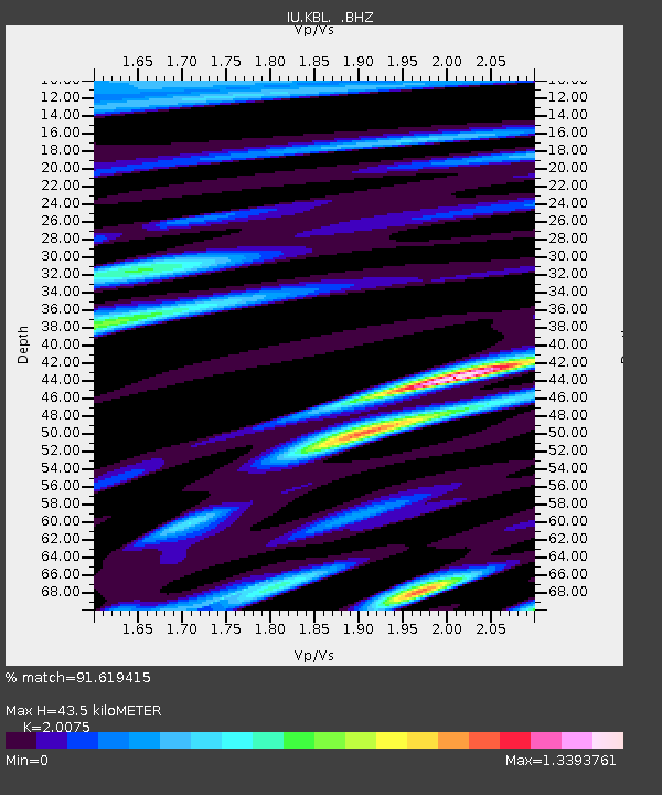
KBL Kabul, Afghanistan - Earthquake Result Viewer
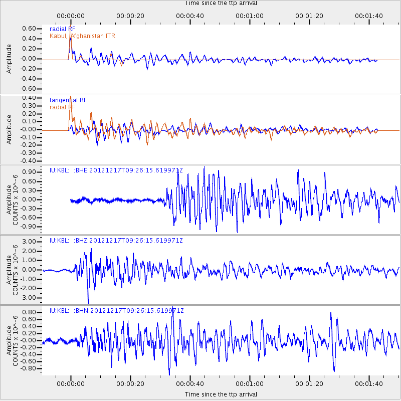
Earthquake location: Minahassa Peninsula, Sulawesi
Earthquake latitude/longitude: -0.6/123.8
Earthquake time(UTC): 2012/12/17 (352) 09:16:30 GMT
Earthquake Depth: 44 km
Earthquake Magnitude: 6.0 MB, 5.6 MS, 6.1 MW, 6.1 MW
Earthquake Catalog/Contributor: WHDF/NEIC
Network: IU Global Seismograph Network (GSN - IRIS/USGS)
Station: KBL Kabul, Afghanistan
Lat/Lon: 34.54 N/69.04 E
Elevation: 1920 m
Distance: 62.0 deg
Az: 310.197 deg
Baz: 112.296 deg
Ray Param: 0.060442314
Estimated Moho Depth: 43.5 km
Estimated Crust Vp/Vs: 2.01
Assumed Crust Vp: 6.641 km/s
Estimated Crust Vs: 3.308 km/s
Estimated Crust Poisson's Ratio: 0.33
Radial Match: 91.619415 %
Radial Bump: 400
Transverse Match: 87.97755 %
Transverse Bump: 400
SOD ConfigId: 491031
Insert Time: 2013-04-05 11:17:39.795 +0000
GWidth: 2.5
Max Bumps: 400
Tol: 0.001

Signal To Noise

ChannelStoNSTALTA
IU:KBL: :BHZ:20121217T09:26:15.619971Z12.4161236.7463696E-75.4335555E-8
IU:KBL: :BHN:20121217T09:26:15.619971Z2.2529939.21316E-84.0892978E-8
IU:KBL: :BHE:20121217T09:26:15.619971Z6.7888562.5999458E-73.829726E-8
Arrivals
Ps6.9 SECOND
PpPs19 SECOND
PsPs/PpSs26 SECOND