You are here: Home > Network List > ND - New CaleDonia Broadband Seismic Network Stations List
> Station MARNC Mare, Loyalty islands, New Caledonia > Earthquake Result Viewer
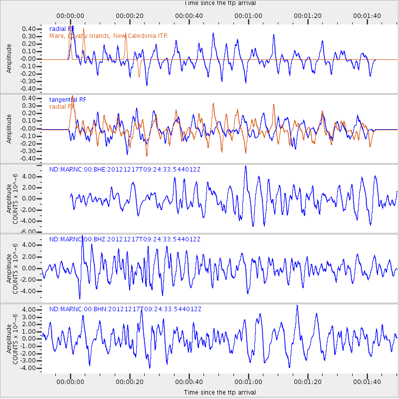
MARNC Mare, Loyalty islands, New Caledonia - Earthquake Result Viewer
*The percent match for this event was below the threshold and hence no stack was calculated.
| Earthquake location: |
Minahassa Peninsula, Sulawesi |
| Earthquake latitude/longitude: |
-0.6/123.8 |
| Earthquake time(UTC): |
2012/12/17 (352) 09:16:30 GMT |
| Earthquake Depth: |
44 km |
| Earthquake Magnitude: |
6.0 MB, 5.6 MS, 6.1 MW, 6.1 MW |
| Earthquake Catalog/Contributor: |
WHDF/NEIC |
|
| Network: |
ND New CaleDonia Broadband Seismic Network |
| Station: |
MARNC Mare, Loyalty islands, New Caledonia |
| Lat/Lon: |
21.48 S/168.03 E |
| Elevation: |
44 m |
|
| Distance: |
47.8 deg |
| Az: |
118.76 deg |
| Baz: |
289.75 deg |
| Ray Param: |
$rayparam |
*The percent match for this event was below the threshold and hence was not used in the summary stack. |
|
| Radial Match: |
62.549232 % |
| Radial Bump: |
342 |
| Transverse Match: |
59.52242 % |
| Transverse Bump: |
400 |
| SOD ConfigId: |
491031 |
| Insert Time: |
2013-04-05 11:18:21.902 +0000 |
| GWidth: |
2.5 |
| Max Bumps: |
400 |
| Tol: |
0.001 |
|
Signal To Noise
| Channel | StoN | STA | LTA |
| ND:MARNC:00:BHZ:20121217T09:24:33.544012Z | 2.3457313 | 2.3046628E-6 | 9.824922E-7 |
| ND:MARNC:00:BHN:20121217T09:24:33.544012Z | 0.9140733 | 1.4033451E-6 | 1.5352655E-6 |
| ND:MARNC:00:BHE:20121217T09:24:33.544012Z | 0.827336 | 9.237642E-7 | 1.1165527E-6 |
| Arrivals |
| Ps | |
| PpPs | |
| PsPs/PpSs | |


