You are here: Home > Network List > AU - Australian Seismological Centre Stations List
> Station MUN Mundaring, Western Australia > Earthquake Result Viewer
MUN Mundaring, Western Australia - Earthquake Result Viewer
| Earthquake location: |
Vanuatu Islands |
| Earthquake latitude/longitude: |
-14.3/167.3 |
| Earthquake time(UTC): |
2012/12/21 (356) 22:28:08 GMT |
| Earthquake Depth: |
201 km |
| Earthquake Magnitude: |
6.1 MB, 6.7 MW, 6.7 MW |
| Earthquake Catalog/Contributor: |
WHDF/NEIC |
|
| Network: |
AU Australian Seismological Centre |
| Station: |
MUN Mundaring, Western Australia |
| Lat/Lon: |
31.98 S/116.21 E |
| Elevation: |
253 m |
|
| Distance: |
49.7 deg |
| Az: |
240.153 deg |
| Baz: |
81.573 deg |
| Ray Param: |
0.06781378 |
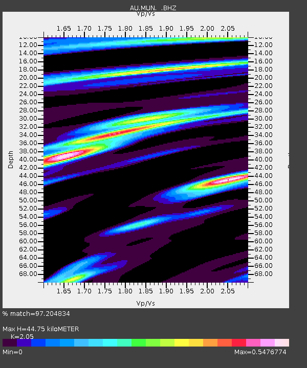
| Estimated Moho Depth: |
44.75 km |
| Estimated Crust Vp/Vs: |
2.05 |
| Assumed Crust Vp: |
6.419 km/s |
| Estimated Crust Vs: |
3.131 km/s |
| Estimated Crust Poisson's Ratio: |
0.34 |
|
| Radial Match: |
97.204834 % |
| Radial Bump: |
292 |
| Transverse Match: |
83.34005 % |
| Transverse Bump: |
400 |
| SOD ConfigId: |
491031 |
| Insert Time: |
2013-04-05 11:27:29.200 +0000 |
| GWidth: |
2.5 |
| Max Bumps: |
400 |
| Tol: |
0.001 |
|

Signal To Noise
| Channel | StoN | STA | LTA |
| AU:MUN: :BHZ:20121221T22:36:09.244988Z | 25.204313 | 6.7764777E-6 | 2.688618E-7 |
| AU:MUN: :BHN:20121221T22:36:09.244988Z | 4.6181507 | 6.878606E-7 | 1.489472E-7 |
| AU:MUN: :BHE:20121221T22:36:09.244988Z | 18.898535 | 4.1842345E-6 | 2.2140524E-7 |
| Arrivals |
| Ps | 7.7 SECOND |
| PpPs | 20 SECOND |
| PsPs/PpSs | 28 SECOND |


