You are here: Home > Network List > AU - Australian Seismological Centre Stations List
> Station BLDU Ballidu, Western Australia > Earthquake Result Viewer
BLDU Ballidu, Western Australia - Earthquake Result Viewer
| Earthquake location: |
Vanuatu Islands |
| Earthquake latitude/longitude: |
-14.3/167.3 |
| Earthquake time(UTC): |
2012/12/21 (356) 22:28:08 GMT |
| Earthquake Depth: |
201 km |
| Earthquake Magnitude: |
6.1 MB, 6.7 MW, 6.7 MW |
| Earthquake Catalog/Contributor: |
WHDF/NEIC |
|
| Network: |
AU Australian Seismological Centre |
| Station: |
BLDU Ballidu, Western Australia |
| Lat/Lon: |
30.61 S/116.71 E |
| Elevation: |
280 m |
|
| Distance: |
49.1 deg |
| Az: |
241.849 deg |
| Baz: |
82.418 deg |
| Ray Param: |
0.06821963 |
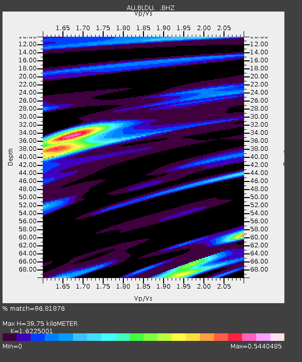
| Estimated Moho Depth: |
39.75 km |
| Estimated Crust Vp/Vs: |
1.62 |
| Assumed Crust Vp: |
6.419 km/s |
| Estimated Crust Vs: |
3.956 km/s |
| Estimated Crust Poisson's Ratio: |
0.19 |
|
| Radial Match: |
96.81876 % |
| Radial Bump: |
251 |
| Transverse Match: |
88.38091 % |
| Transverse Bump: |
400 |
| SOD ConfigId: |
491031 |
| Insert Time: |
2013-04-05 11:27:38.812 +0000 |
| GWidth: |
2.5 |
| Max Bumps: |
400 |
| Tol: |
0.001 |
|

Signal To Noise
| Channel | StoN | STA | LTA |
| AU:BLDU: :BHZ:20121221T22:36:04.594994Z | 29.592232 | 7.474307E-6 | 2.5257665E-7 |
| AU:BLDU: :BHN:20121221T22:36:04.594994Z | 9.020153 | 1.7210308E-6 | 1.907984E-7 |
| AU:BLDU: :BHE:20121221T22:36:04.594994Z | 27.613054 | 4.153374E-6 | 1.5041341E-7 |
| Arrivals |
| Ps | 4.1 SECOND |
| PpPs | 15 SECOND |
| PsPs/PpSs | 19 SECOND |


