You are here: Home > Network List > AU - Australian Seismological Centre Stations List
> Station MOO Moorlands, Tasmania > Earthquake Result Viewer
MOO Moorlands, Tasmania - Earthquake Result Viewer
| Earthquake location: |
Vanuatu Islands |
| Earthquake latitude/longitude: |
-14.3/167.3 |
| Earthquake time(UTC): |
2012/12/21 (356) 22:28:08 GMT |
| Earthquake Depth: |
201 km |
| Earthquake Magnitude: |
6.1 MB, 6.7 MW, 6.7 MW |
| Earthquake Catalog/Contributor: |
WHDF/NEIC |
|
| Network: |
AU Australian Seismological Centre |
| Station: |
MOO Moorlands, Tasmania |
| Lat/Lon: |
42.44 S/147.19 E |
| Elevation: |
325 m |
|
| Distance: |
32.9 deg |
| Az: |
207.891 deg |
| Baz: |
37.771 deg |
| Ray Param: |
0.07779497 |
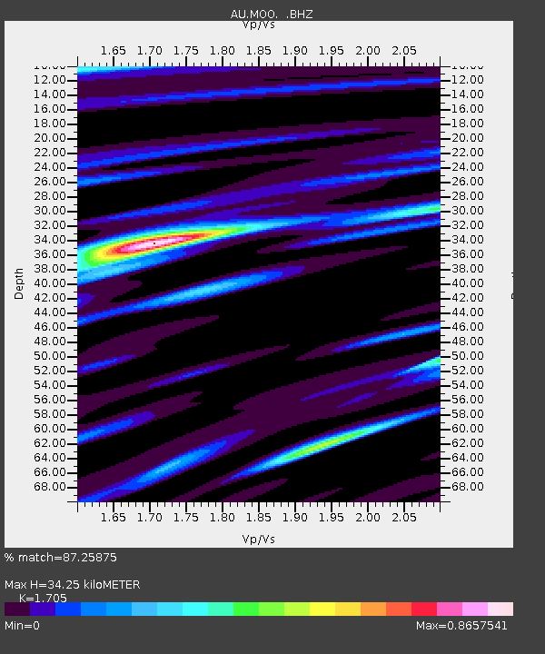
| Estimated Moho Depth: |
34.25 km |
| Estimated Crust Vp/Vs: |
1.71 |
| Assumed Crust Vp: |
6.477 km/s |
| Estimated Crust Vs: |
3.799 km/s |
| Estimated Crust Poisson's Ratio: |
0.24 |
|
| Radial Match: |
87.25875 % |
| Radial Bump: |
359 |
| Transverse Match: |
63.29209 % |
| Transverse Bump: |
400 |
| SOD ConfigId: |
491031 |
| Insert Time: |
2013-04-05 11:28:00.323 +0000 |
| GWidth: |
2.5 |
| Max Bumps: |
400 |
| Tol: |
0.001 |
|

Signal To Noise
| Channel | StoN | STA | LTA |
| AU:MOO: :BHZ:20121221T22:33:53.645012Z | 8.354715 | 7.7186405E-6 | 9.2386637E-7 |
| AU:MOO: :BHN:20121221T22:33:53.645012Z | 5.9082584 | 4.362033E-6 | 7.3829426E-7 |
| AU:MOO: :BHE:20121221T22:33:53.645012Z | 3.7266636 | 3.0674332E-6 | 8.231044E-7 |
| Arrivals |
| Ps | 4.0 SECOND |
| PpPs | 13 SECOND |
| PsPs/PpSs | 17 SECOND |


