You are here: Home > Network List > CI - Caltech Regional Seismic Network Stations List
> Station BAR Barrett, Tecate, CA, USA > Earthquake Result Viewer
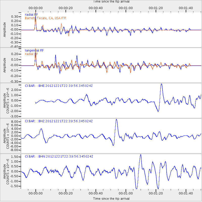
BAR Barrett, Tecate, CA, USA - Earthquake Result Viewer
*The percent match for this event was below the threshold and hence no stack was calculated.
| Earthquake location: |
Vanuatu Islands |
| Earthquake latitude/longitude: |
-14.3/167.3 |
| Earthquake time(UTC): |
2012/12/21 (356) 22:28:08 GMT |
| Earthquake Depth: |
201 km |
| Earthquake Magnitude: |
6.1 MB, 6.7 MW, 6.7 MW |
| Earthquake Catalog/Contributor: |
WHDF/NEIC |
|
| Network: |
CI Caltech Regional Seismic Network |
| Station: |
BAR Barrett, Tecate, CA, USA |
| Lat/Lon: |
32.68 N/116.67 W |
| Elevation: |
521 m |
|
| Distance: |
86.3 deg |
| Az: |
55.101 deg |
| Baz: |
250.491 deg |
| Ray Param: |
$rayparam |
*The percent match for this event was below the threshold and hence was not used in the summary stack. |
|
| Radial Match: |
75.187874 % |
| Radial Bump: |
400 |
| Transverse Match: |
83.45494 % |
| Transverse Bump: |
400 |
| SOD ConfigId: |
491031 |
| Insert Time: |
2013-04-05 11:31:04.099 +0000 |
| GWidth: |
2.5 |
| Max Bumps: |
400 |
| Tol: |
0.001 |
|
Signal To Noise
| Channel | StoN | STA | LTA |
| CI:BAR: :BHZ:20121221T22:39:56.345024Z | 3.9254832 | 2.3036375E-6 | 5.868418E-7 |
| CI:BAR: :BHN:20121221T22:39:56.345024Z | 0.62235916 | 1.5450783E-7 | 2.4826153E-7 |
| CI:BAR: :BHE:20121221T22:39:56.345024Z | 3.2338321 | 6.442639E-7 | 1.9922614E-7 |
| Arrivals |
| Ps | |
| PpPs | |
| PsPs/PpSs | |


