You are here: Home > Network List > CI - Caltech Regional Seismic Network Stations List
> Station FUR Furnace Creek, CA, USA > Earthquake Result Viewer
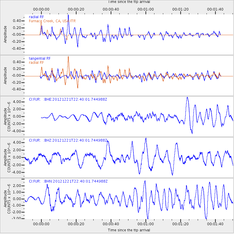
FUR Furnace Creek, CA, USA - Earthquake Result Viewer
*The percent match for this event was below the threshold and hence no stack was calculated.
| Earthquake location: |
Vanuatu Islands |
| Earthquake latitude/longitude: |
-14.3/167.3 |
| Earthquake time(UTC): |
2012/12/21 (356) 22:28:08 GMT |
| Earthquake Depth: |
201 km |
| Earthquake Magnitude: |
6.1 MB, 6.7 MW, 6.7 MW |
| Earthquake Catalog/Contributor: |
WHDF/NEIC |
|
| Network: |
CI Caltech Regional Seismic Network |
| Station: |
FUR Furnace Creek, CA, USA |
| Lat/Lon: |
36.47 N/116.86 W |
| Elevation: |
-37.0 m |
|
| Distance: |
87.4 deg |
| Az: |
51.485 deg |
| Baz: |
250.184 deg |
| Ray Param: |
$rayparam |
*The percent match for this event was below the threshold and hence was not used in the summary stack. |
|
| Radial Match: |
49.069344 % |
| Radial Bump: |
400 |
| Transverse Match: |
41.717876 % |
| Transverse Bump: |
400 |
| SOD ConfigId: |
491031 |
| Insert Time: |
2013-04-05 11:32:07.567 +0000 |
| GWidth: |
2.5 |
| Max Bumps: |
400 |
| Tol: |
0.001 |
|
Signal To Noise
| Channel | StoN | STA | LTA |
| CI:FUR: :BHZ:20121221T22:40:01.744988Z | 0.7591567 | 8.812538E-7 | 1.1608325E-6 |
| CI:FUR: :BHN:20121221T22:40:01.744988Z | 2.2796545 | 1.0483172E-6 | 4.5985794E-7 |
| CI:FUR: :BHE:20121221T22:40:01.744988Z | 1.7944295 | 8.465697E-7 | 4.7177653E-7 |
| Arrivals |
| Ps | |
| PpPs | |
| PsPs/PpSs | |


