You are here: Home > Network List > CI - Caltech Regional Seismic Network Stations List
> Station LGU LGU, Camarillo, CA, USA > Earthquake Result Viewer
LGU LGU, Camarillo, CA, USA - Earthquake Result Viewer

| Earthquake location: |
Vanuatu Islands |
| Earthquake latitude/longitude: |
-14.3/167.3 |
| Earthquake time(UTC): |
2012/12/21 (356) 22:28:08 GMT |
| Earthquake Depth: |
201 km |
| Earthquake Magnitude: |
6.1 MB, 6.7 MW, 6.7 MW |
| Earthquake Catalog/Contributor: |
WHDF/NEIC |
|
| Network: |
CI Caltech Regional Seismic Network |
| Station: |
LGU LGU, Camarillo, CA, USA |
| Lat/Lon: |
34.11 N/119.07 W |
| Elevation: |
416 m |
|
| Distance: |
84.9 deg |
| Az: |
53.066 deg |
| Baz: |
249.023 deg |
| Ray Param: |
0.044674996 |
| Estimated Moho Depth: |
31.0 km |
| Estimated Crust Vp/Vs: |
1.60 |
| Assumed Crust Vp: |
6.1 km/s |
| Estimated Crust Vs: |
3.812 km/s |
| Estimated Crust Poisson's Ratio: |
0.18 |
|
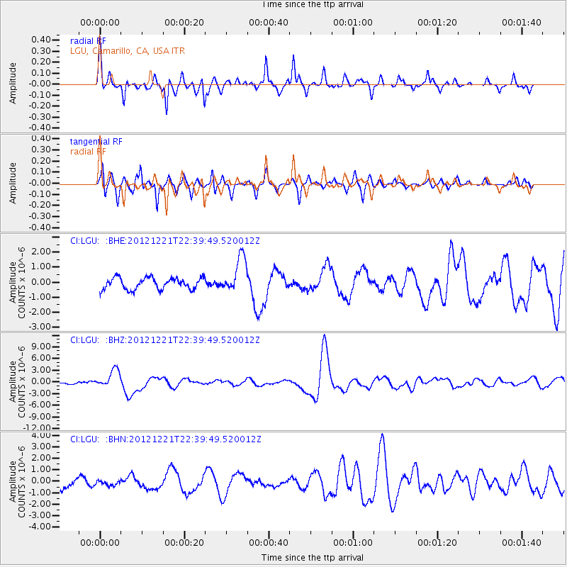
| Radial Match: |
85.748505 % |
| Radial Bump: |
328 |
| Transverse Match: |
71.745384 % |
| Transverse Bump: |
316 |
| SOD ConfigId: |
491031 |
| Insert Time: |
2013-04-05 11:33:01.138 +0000 |
| GWidth: |
2.5 |
| Max Bumps: |
400 |
| Tol: |
0.001 |
|
Signal To Noise
| Channel | StoN | STA | LTA |
| CI:LGU: :BHZ:20121221T22:39:49.520012Z | 3.951706 | 2.360844E-6 | 5.9742405E-7 |
| CI:LGU: :BHN:20121221T22:39:49.520012Z | 0.25482297 | 2.0841497E-7 | 8.1788136E-7 |
| CI:LGU: :BHE:20121221T22:39:49.520012Z | 3.1944904 | 1.2274052E-6 | 3.8422567E-7 |
| Arrivals |
| Ps | 3.1 SECOND |
| PpPs | 13 SECOND |
| PsPs/PpSs | 16 SECOND |


