You are here: Home > Network List > GE - GEOFON Stations List
> Station SNAA GEOFON/AWI Station Sanae, Antarctica > Earthquake Result Viewer
SNAA GEOFON/AWI Station Sanae, Antarctica - Earthquake Result Viewer
| Earthquake location: |
Vanuatu Islands |
| Earthquake latitude/longitude: |
-14.3/167.3 |
| Earthquake time(UTC): |
2012/12/21 (356) 22:28:08 GMT |
| Earthquake Depth: |
201 km |
| Earthquake Magnitude: |
6.1 MB, 6.7 MW, 6.7 MW |
| Earthquake Catalog/Contributor: |
WHDF/NEIC |
|
| Network: |
GE GEOFON |
| Station: |
SNAA GEOFON/AWI Station Sanae, Antarctica |
| Lat/Lon: |
71.67 S/2.84 W |
| Elevation: |
846 m |
|
| Distance: |
93.9 deg |
| Az: |
183.118 deg |
| Baz: |
170.408 deg |
| Ray Param: |
0.041020095 |
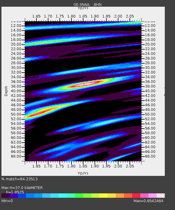
| Estimated Moho Depth: |
37.0 km |
| Estimated Crust Vp/Vs: |
1.85 |
| Assumed Crust Vp: |
6.43 km/s |
| Estimated Crust Vs: |
3.471 km/s |
| Estimated Crust Poisson's Ratio: |
0.29 |
|
| Radial Match: |
94.23513 % |
| Radial Bump: |
400 |
| Transverse Match: |
73.94061 % |
| Transverse Bump: |
400 |
| SOD ConfigId: |
491031 |
| Insert Time: |
2013-04-05 11:34:51.804 +0000 |
| GWidth: |
2.5 |
| Max Bumps: |
400 |
| Tol: |
0.001 |
|
Signal To Noise
| Channel | StoN | STA | LTA |
| GE:SNAA: :BHZ:20121221T22:40:31.960991Z | 48.178368 | 1.5532784E-4 | 3.2240162E-6 |
| GE:SNAA: :BHN:20121221T22:40:31.960991Z | 19.83752 | 5.260545E-5 | 2.651816E-6 |
| GE:SNAA: :BHE:20121221T22:40:31.960991Z | 3.9799197 | 1.3033648E-5 | 3.2748521E-6 |
| Arrivals |
| Ps | 5.0 SECOND |
| PpPs | 16 SECOND |
| PsPs/PpSs | 21 SECOND |


