You are here: Home > Network List > TA - USArray Transportable Network (new EarthScope stations) Stations List
> Station N23A Red Feather Lakes, CO, USA > Earthquake Result Viewer
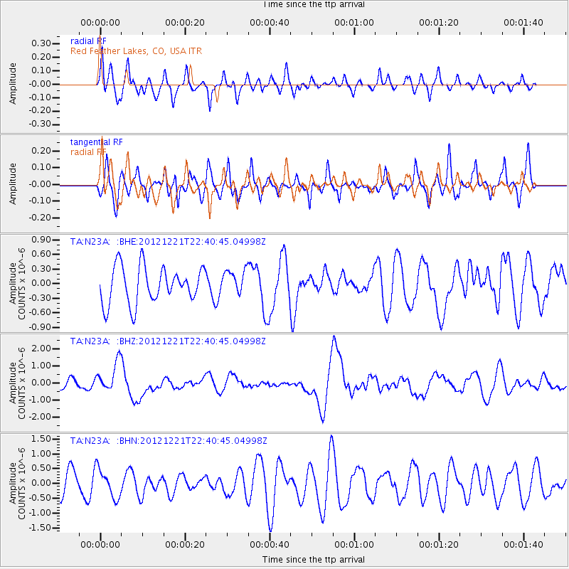
N23A Red Feather Lakes, CO, USA - Earthquake Result Viewer
*The percent match for this event was below the threshold and hence no stack was calculated.
| Earthquake location: |
Vanuatu Islands |
| Earthquake latitude/longitude: |
-14.3/167.3 |
| Earthquake time(UTC): |
2012/12/21 (356) 22:28:08 GMT |
| Earthquake Depth: |
201 km |
| Earthquake Magnitude: |
6.1 MB, 6.7 MW, 6.7 MW |
| Earthquake Catalog/Contributor: |
WHDF/NEIC |
|
| Network: |
TA USArray Transportable Network (new EarthScope stations) |
| Station: |
N23A Red Feather Lakes, CO, USA |
| Lat/Lon: |
40.89 N/105.94 W |
| Elevation: |
2458 m |
|
| Distance: |
96.8 deg |
| Az: |
49.668 deg |
| Baz: |
257.065 deg |
| Ray Param: |
$rayparam |
*The percent match for this event was below the threshold and hence was not used in the summary stack. |
|
| Radial Match: |
49.041527 % |
| Radial Bump: |
400 |
| Transverse Match: |
35.775703 % |
| Transverse Bump: |
320 |
| SOD ConfigId: |
491031 |
| Insert Time: |
2013-04-05 11:39:01.657 +0000 |
| GWidth: |
2.5 |
| Max Bumps: |
400 |
| Tol: |
0.001 |
|
Signal To Noise
| Channel | StoN | STA | LTA |
| TA:N23A: :BHZ:20121221T22:40:45.04998Z | 3.1320922 | 8.9113576E-7 | 2.8451774E-7 |
| TA:N23A: :BHN:20121221T22:40:45.04998Z | 1.407735 | 4.7998816E-7 | 3.4096487E-7 |
| TA:N23A: :BHE:20121221T22:40:45.04998Z | 0.6836711 | 2.5740565E-7 | 3.7650508E-7 |
| Arrivals |
| Ps | |
| PpPs | |
| PsPs/PpSs | |


