You are here: Home > Network List > TA - USArray Transportable Network (new EarthScope stations) Stations List
> Station J05D Fort Rock, OR, USA > Earthquake Result Viewer
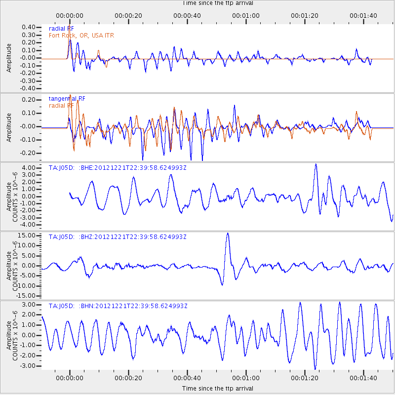
J05D Fort Rock, OR, USA - Earthquake Result Viewer
*The percent match for this event was below the threshold and hence no stack was calculated.
| Earthquake location: |
Vanuatu Islands |
| Earthquake latitude/longitude: |
-14.3/167.3 |
| Earthquake time(UTC): |
2012/12/21 (356) 22:28:08 GMT |
| Earthquake Depth: |
201 km |
| Earthquake Magnitude: |
6.1 MB, 6.7 MW, 6.7 MW |
| Earthquake Catalog/Contributor: |
WHDF/NEIC |
|
| Network: |
TA USArray Transportable Network (new EarthScope stations) |
| Station: |
J05D Fort Rock, OR, USA |
| Lat/Lon: |
43.28 N/121.23 W |
| Elevation: |
1541 m |
|
| Distance: |
86.8 deg |
| Az: |
43.911 deg |
| Baz: |
247.0 deg |
| Ray Param: |
$rayparam |
*The percent match for this event was below the threshold and hence was not used in the summary stack. |
|
| Radial Match: |
55.737225 % |
| Radial Bump: |
362 |
| Transverse Match: |
68.08718 % |
| Transverse Bump: |
319 |
| SOD ConfigId: |
491031 |
| Insert Time: |
2013-04-05 11:39:12.646 +0000 |
| GWidth: |
2.5 |
| Max Bumps: |
400 |
| Tol: |
0.001 |
|
Signal To Noise
| Channel | StoN | STA | LTA |
| TA:J05D: :BHZ:20121221T22:39:58.624993Z | 3.4702816 | 2.6639816E-6 | 7.6765576E-7 |
| TA:J05D: :BHN:20121221T22:39:58.624993Z | 0.95877177 | 9.850316E-7 | 1.0273891E-6 |
| TA:J05D: :BHE:20121221T22:39:58.624993Z | 1.1739559 | 1.5596637E-6 | 1.3285538E-6 |
| Arrivals |
| Ps | |
| PpPs | |
| PsPs/PpSs | |


