You are here: Home > Network List > TA - USArray Transportable Network (new EarthScope stations) Stations List
> Station G05D Wamic, OR, USA > Earthquake Result Viewer
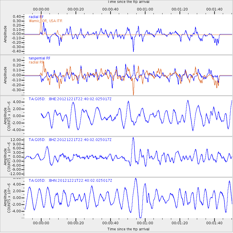
G05D Wamic, OR, USA - Earthquake Result Viewer
*The percent match for this event was below the threshold and hence no stack was calculated.
| Earthquake location: |
Vanuatu Islands |
| Earthquake latitude/longitude: |
-14.3/167.3 |
| Earthquake time(UTC): |
2012/12/21 (356) 22:28:08 GMT |
| Earthquake Depth: |
201 km |
| Earthquake Magnitude: |
6.1 MB, 6.7 MW, 6.7 MW |
| Earthquake Catalog/Contributor: |
WHDF/NEIC |
|
| Network: |
TA USArray Transportable Network (new EarthScope stations) |
| Station: |
G05D Wamic, OR, USA |
| Lat/Lon: |
45.24 N/121.32 W |
| Elevation: |
592 m |
|
| Distance: |
87.5 deg |
| Az: |
42.085 deg |
| Baz: |
246.851 deg |
| Ray Param: |
$rayparam |
*The percent match for this event was below the threshold and hence was not used in the summary stack. |
|
| Radial Match: |
57.57309 % |
| Radial Bump: |
379 |
| Transverse Match: |
61.72383 % |
| Transverse Bump: |
400 |
| SOD ConfigId: |
491031 |
| Insert Time: |
2013-04-05 11:39:24.894 +0000 |
| GWidth: |
2.5 |
| Max Bumps: |
400 |
| Tol: |
0.001 |
|
Signal To Noise
| Channel | StoN | STA | LTA |
| TA:G05D: :BHZ:20121221T22:40:02.025017Z | 4.8755465 | 3.7275222E-6 | 7.6453426E-7 |
| TA:G05D: :BHN:20121221T22:40:02.025017Z | 1.2330246 | 2.1422234E-6 | 1.7373727E-6 |
| TA:G05D: :BHE:20121221T22:40:02.025017Z | 0.98844314 | 1.8247938E-6 | 1.8461293E-6 |
| Arrivals |
| Ps | |
| PpPs | |
| PsPs/PpSs | |


