You are here: Home > Network List > TA - USArray Transportable Network (new EarthScope stations) Stations List
> Station G03D McMinnville, OR, USA > Earthquake Result Viewer
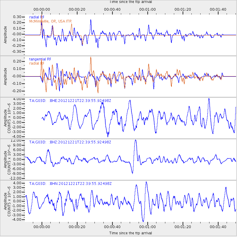
G03D McMinnville, OR, USA - Earthquake Result Viewer
*The percent match for this event was below the threshold and hence no stack was calculated.
| Earthquake location: |
Vanuatu Islands |
| Earthquake latitude/longitude: |
-14.3/167.3 |
| Earthquake time(UTC): |
2012/12/21 (356) 22:28:08 GMT |
| Earthquake Depth: |
201 km |
| Earthquake Magnitude: |
6.1 MB, 6.7 MW, 6.7 MW |
| Earthquake Catalog/Contributor: |
WHDF/NEIC |
|
| Network: |
TA USArray Transportable Network (new EarthScope stations) |
| Station: |
G03D McMinnville, OR, USA |
| Lat/Lon: |
45.21 N/123.26 W |
| Elevation: |
222 m |
|
| Distance: |
86.2 deg |
| Az: |
41.556 deg |
| Baz: |
245.443 deg |
| Ray Param: |
$rayparam |
*The percent match for this event was below the threshold and hence was not used in the summary stack. |
|
| Radial Match: |
73.590965 % |
| Radial Bump: |
400 |
| Transverse Match: |
58.1959 % |
| Transverse Bump: |
400 |
| SOD ConfigId: |
491031 |
| Insert Time: |
2013-04-05 11:39:32.507 +0000 |
| GWidth: |
2.5 |
| Max Bumps: |
400 |
| Tol: |
0.001 |
|
Signal To Noise
| Channel | StoN | STA | LTA |
| TA:G03D: :BHZ:20121221T22:39:55.92498Z | 2.2955644 | 3.179965E-6 | 1.385265E-6 |
| TA:G03D: :BHN:20121221T22:39:55.92498Z | 0.8827237 | 8.884864E-7 | 1.0065284E-6 |
| TA:G03D: :BHE:20121221T22:39:55.92498Z | 1.6589202 | 1.940231E-6 | 1.1695747E-6 |
| Arrivals |
| Ps | |
| PpPs | |
| PsPs/PpSs | |


