You are here: Home > Network List > TA - USArray Transportable Network (new EarthScope stations) Stations List
> Station TPFO Pinon Flats, CA, USA > Earthquake Result Viewer
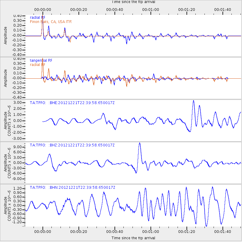
TPFO Pinon Flats, CA, USA - Earthquake Result Viewer
*The percent match for this event was below the threshold and hence no stack was calculated.
| Earthquake location: |
Vanuatu Islands |
| Earthquake latitude/longitude: |
-14.3/167.3 |
| Earthquake time(UTC): |
2012/12/21 (356) 22:28:08 GMT |
| Earthquake Depth: |
201 km |
| Earthquake Magnitude: |
6.1 MB, 6.7 MW, 6.7 MW |
| Earthquake Catalog/Contributor: |
WHDF/NEIC |
|
| Network: |
TA USArray Transportable Network (new EarthScope stations) |
| Station: |
TPFO Pinon Flats, CA, USA |
| Lat/Lon: |
33.61 N/116.45 W |
| Elevation: |
1275 m |
|
| Distance: |
86.8 deg |
| Az: |
54.29 deg |
| Baz: |
250.56 deg |
| Ray Param: |
$rayparam |
*The percent match for this event was below the threshold and hence was not used in the summary stack. |
|
| Radial Match: |
79.47511 % |
| Radial Bump: |
300 |
| Transverse Match: |
69.27288 % |
| Transverse Bump: |
367 |
| SOD ConfigId: |
491031 |
| Insert Time: |
2013-04-05 11:39:51.346 +0000 |
| GWidth: |
2.5 |
| Max Bumps: |
400 |
| Tol: |
0.001 |
|
Signal To Noise
| Channel | StoN | STA | LTA |
| TA:TPFO: :BHZ:20121221T22:39:58.650017Z | 5.4901056 | 2.6348282E-6 | 4.799231E-7 |
| TA:TPFO: :BHN:20121221T22:39:58.650017Z | 0.7645416 | 1.5832079E-7 | 2.0707937E-7 |
| TA:TPFO: :BHE:20121221T22:39:58.650017Z | 2.1576962 | 6.276981E-7 | 2.9091126E-7 |
| Arrivals |
| Ps | |
| PpPs | |
| PsPs/PpSs | |


