You are here: Home > Network List > TA - USArray Transportable Network (new EarthScope stations) Stations List
> Station O41A Passley's Farm, La Prairie, IL, USA > Earthquake Result Viewer
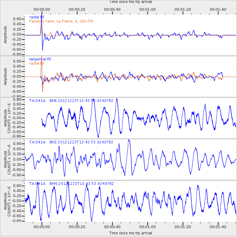
O41A Passley's Farm, La Prairie, IL, USA - Earthquake Result Viewer
*The percent match for this event was below the threshold and hence no stack was calculated.
| Earthquake location: |
Northwestern Caucasus |
| Earthquake latitude/longitude: |
42.4/41.1 |
| Earthquake time(UTC): |
2012/12/23 (358) 13:31:40 GMT |
| Earthquake Depth: |
15 km |
| Earthquake Magnitude: |
5.5 MB, 5.6 MS, 5.7 MW, 5.6 MW |
| Earthquake Catalog/Contributor: |
WHDF/NEIC |
|
| Network: |
TA USArray Transportable Network (new EarthScope stations) |
| Station: |
O41A Passley's Farm, La Prairie, IL, USA |
| Lat/Lon: |
40.12 N/90.88 W |
| Elevation: |
203 m |
|
| Distance: |
87.0 deg |
| Az: |
325.177 deg |
| Baz: |
33.462 deg |
| Ray Param: |
$rayparam |
*The percent match for this event was below the threshold and hence was not used in the summary stack. |
|
| Radial Match: |
51.053726 % |
| Radial Bump: |
400 |
| Transverse Match: |
54.50279 % |
| Transverse Bump: |
400 |
| SOD ConfigId: |
491031 |
| Insert Time: |
2013-04-10 03:49:13.848 +0000 |
| GWidth: |
2.5 |
| Max Bumps: |
400 |
| Tol: |
0.001 |
|
Signal To Noise
| Channel | StoN | STA | LTA |
| TA:O41A: :BHZ:20121223T13:43:53.924978Z | 0.49339205 | 1.5800023E-7 | 3.2023263E-7 |
| TA:O41A: :BHN:20121223T13:43:53.924978Z | 1.3793005 | 4.5410928E-7 | 3.292316E-7 |
| TA:O41A: :BHE:20121223T13:43:53.924978Z | 2.028327 | 5.174236E-7 | 2.550987E-7 |
| Arrivals |
| Ps | |
| PpPs | |
| PsPs/PpSs | |


