You are here: Home > Network List > TA - USArray Transportable Network (new EarthScope stations) Stations List
> Station W53A Cullowhee, NC, USA > Earthquake Result Viewer
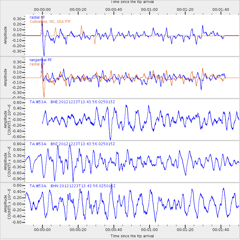
W53A Cullowhee, NC, USA - Earthquake Result Viewer
*The percent match for this event was below the threshold and hence no stack was calculated.
| Earthquake location: |
Northwestern Caucasus |
| Earthquake latitude/longitude: |
42.4/41.1 |
| Earthquake time(UTC): |
2012/12/23 (358) 13:31:40 GMT |
| Earthquake Depth: |
15 km |
| Earthquake Magnitude: |
5.5 MB, 5.6 MS, 5.7 MW, 5.6 MW |
| Earthquake Catalog/Contributor: |
WHDF/NEIC |
|
| Network: |
TA USArray Transportable Network (new EarthScope stations) |
| Station: |
W53A Cullowhee, NC, USA |
| Lat/Lon: |
35.17 N/83.16 W |
| Elevation: |
1180 m |
|
| Distance: |
87.5 deg |
| Az: |
317.316 deg |
| Baz: |
37.789 deg |
| Ray Param: |
$rayparam |
*The percent match for this event was below the threshold and hence was not used in the summary stack. |
|
| Radial Match: |
69.535355 % |
| Radial Bump: |
400 |
| Transverse Match: |
75.73167 % |
| Transverse Bump: |
400 |
| SOD ConfigId: |
491031 |
| Insert Time: |
2013-04-10 03:50:52.681 +0000 |
| GWidth: |
2.5 |
| Max Bumps: |
400 |
| Tol: |
0.001 |
|
Signal To Noise
| Channel | StoN | STA | LTA |
| TA:W53A: :BHZ:20121223T13:43:56.025015Z | 2.206304 | 4.5339723E-7 | 2.055008E-7 |
| TA:W53A: :BHN:20121223T13:43:56.025015Z | 1.8076327 | 3.2187248E-7 | 1.7806298E-7 |
| TA:W53A: :BHE:20121223T13:43:56.025015Z | 1.7401918 | 2.010445E-7 | 1.1553008E-7 |
| Arrivals |
| Ps | |
| PpPs | |
| PsPs/PpSs | |


