You are here: Home > Network List > TA - USArray Transportable Network (new EarthScope stations) Stations List
> Station T52A Hallie, KY, USA > Earthquake Result Viewer
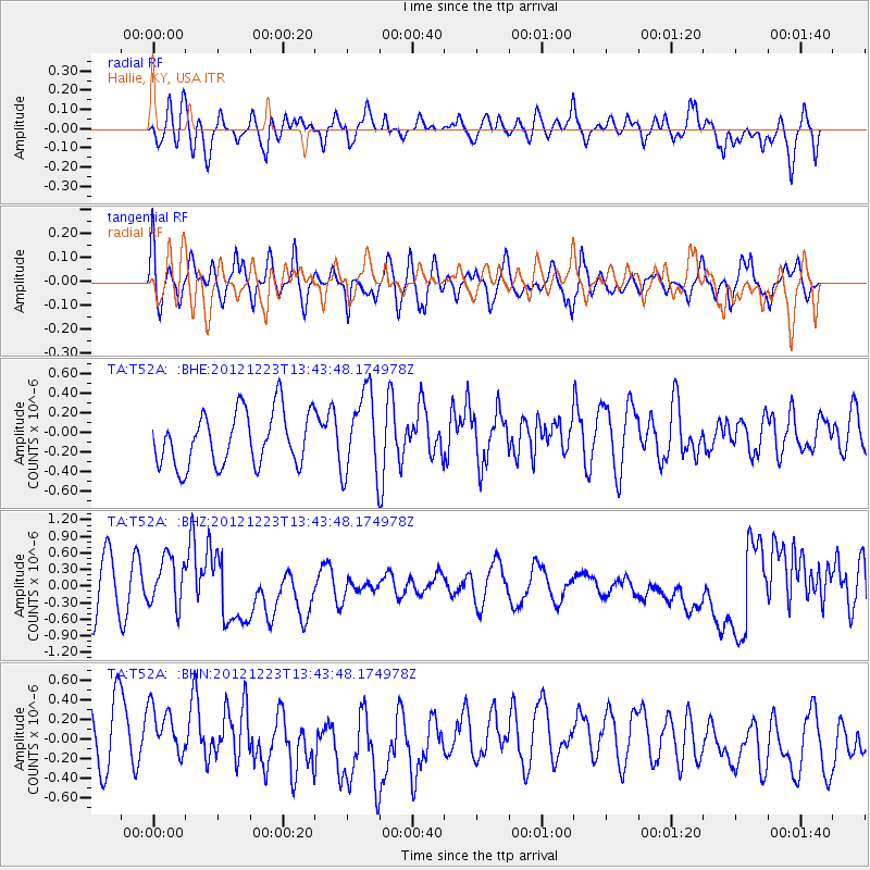
T52A Hallie, KY, USA - Earthquake Result Viewer
*The percent match for this event was below the threshold and hence no stack was calculated.
| Earthquake location: |
Northwestern Caucasus |
| Earthquake latitude/longitude: |
42.4/41.1 |
| Earthquake time(UTC): |
2012/12/23 (358) 13:31:40 GMT |
| Earthquake Depth: |
15 km |
| Earthquake Magnitude: |
5.5 MB, 5.6 MS, 5.7 MW, 5.6 MW |
| Earthquake Catalog/Contributor: |
WHDF/NEIC |
|
| Network: |
TA USArray Transportable Network (new EarthScope stations) |
| Station: |
T52A Hallie, KY, USA |
| Lat/Lon: |
37.11 N/82.99 W |
| Elevation: |
436 m |
|
| Distance: |
85.9 deg |
| Az: |
318.392 deg |
| Baz: |
37.955 deg |
| Ray Param: |
$rayparam |
*The percent match for this event was below the threshold and hence was not used in the summary stack. |
|
| Radial Match: |
60.49918 % |
| Radial Bump: |
400 |
| Transverse Match: |
59.887035 % |
| Transverse Bump: |
400 |
| SOD ConfigId: |
491031 |
| Insert Time: |
2013-04-10 03:51:05.443 +0000 |
| GWidth: |
2.5 |
| Max Bumps: |
400 |
| Tol: |
0.001 |
|
Signal To Noise
| Channel | StoN | STA | LTA |
| TA:T52A: :BHZ:20121223T13:43:48.174978Z | 0.8968749 | 4.2746487E-7 | 4.7661595E-7 |
| TA:T52A: :BHN:20121223T13:43:48.174978Z | 0.9558882 | 3.5344664E-7 | 3.697573E-7 |
| TA:T52A: :BHE:20121223T13:43:48.174978Z | 1.5577981 | 4.2304598E-7 | 2.7156662E-7 |
| Arrivals |
| Ps | |
| PpPs | |
| PsPs/PpSs | |


