You are here: Home > Network List > TA - USArray Transportable Network (new EarthScope stations) Stations List
> Station M49A Liberty Center, OH, USA > Earthquake Result Viewer
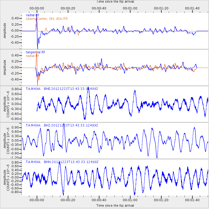
M49A Liberty Center, OH, USA - Earthquake Result Viewer
*The percent match for this event was below the threshold and hence no stack was calculated.
| Earthquake location: |
Northwestern Caucasus |
| Earthquake latitude/longitude: |
42.4/41.1 |
| Earthquake time(UTC): |
2012/12/23 (358) 13:31:40 GMT |
| Earthquake Depth: |
15 km |
| Earthquake Magnitude: |
5.5 MB, 5.6 MS, 5.7 MW, 5.6 MW |
| Earthquake Catalog/Contributor: |
WHDF/NEIC |
|
| Network: |
TA USArray Transportable Network (new EarthScope stations) |
| Station: |
M49A Liberty Center, OH, USA |
| Lat/Lon: |
41.47 N/83.98 W |
| Elevation: |
203 m |
|
| Distance: |
82.9 deg |
| Az: |
321.687 deg |
| Baz: |
37.654 deg |
| Ray Param: |
$rayparam |
*The percent match for this event was below the threshold and hence was not used in the summary stack. |
|
| Radial Match: |
65.538895 % |
| Radial Bump: |
400 |
| Transverse Match: |
43.41907 % |
| Transverse Bump: |
400 |
| SOD ConfigId: |
491031 |
| Insert Time: |
2013-04-10 03:51:39.532 +0000 |
| GWidth: |
2.5 |
| Max Bumps: |
400 |
| Tol: |
0.001 |
|
Signal To Noise
| Channel | StoN | STA | LTA |
| TA:M49A: :BHZ:20121223T13:43:33.12499Z | 1.6951011 | 5.6179135E-7 | 3.3142052E-7 |
| TA:M49A: :BHN:20121223T13:43:33.12499Z | 0.3502132 | 1.3578318E-7 | 3.8771574E-7 |
| TA:M49A: :BHE:20121223T13:43:33.12499Z | 2.4870229 | 6.00984E-7 | 2.4164797E-7 |
| Arrivals |
| Ps | |
| PpPs | |
| PsPs/PpSs | |


