You are here: Home > Network List > TA - USArray Transportable Network (new EarthScope stations) Stations List
> Station I45A Fountain, MI, USA > Earthquake Result Viewer
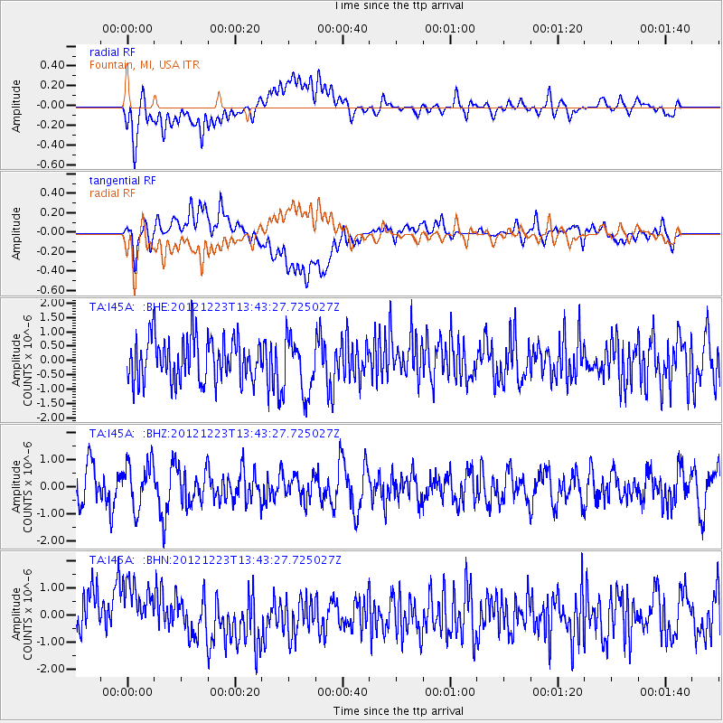
I45A Fountain, MI, USA - Earthquake Result Viewer
*The percent match for this event was below the threshold and hence no stack was calculated.
| Earthquake location: |
Northwestern Caucasus |
| Earthquake latitude/longitude: |
42.4/41.1 |
| Earthquake time(UTC): |
2012/12/23 (358) 13:31:40 GMT |
| Earthquake Depth: |
15 km |
| Earthquake Magnitude: |
5.5 MB, 5.6 MS, 5.7 MW, 5.6 MW |
| Earthquake Catalog/Contributor: |
WHDF/NEIC |
|
| Network: |
TA USArray Transportable Network (new EarthScope stations) |
| Station: |
I45A Fountain, MI, USA |
| Lat/Lon: |
44.04 N/86.23 W |
| Elevation: |
215 m |
|
| Distance: |
81.8 deg |
| Az: |
324.584 deg |
| Baz: |
36.51 deg |
| Ray Param: |
$rayparam |
*The percent match for this event was below the threshold and hence was not used in the summary stack. |
|
| Radial Match: |
59.385185 % |
| Radial Bump: |
400 |
| Transverse Match: |
63.142216 % |
| Transverse Bump: |
400 |
| SOD ConfigId: |
491031 |
| Insert Time: |
2013-04-10 03:52:03.737 +0000 |
| GWidth: |
2.5 |
| Max Bumps: |
400 |
| Tol: |
0.001 |
|
Signal To Noise
| Channel | StoN | STA | LTA |
| TA:I45A: :BHZ:20121223T13:43:27.725027Z | 1.2762793 | 8.466296E-7 | 6.633576E-7 |
| TA:I45A: :BHN:20121223T13:43:27.725027Z | 1.4746363 | 1.0948236E-6 | 7.424363E-7 |
| TA:I45A: :BHE:20121223T13:43:27.725027Z | 1.3147041 | 9.959742E-7 | 7.575654E-7 |
| Arrivals |
| Ps | |
| PpPs | |
| PsPs/PpSs | |


