You are here: Home > Network List > TA - USArray Transportable Network (new EarthScope stations) Stations List
> Station J04D Umpqua National Forest, Toketee, OR, USA > Earthquake Result Viewer
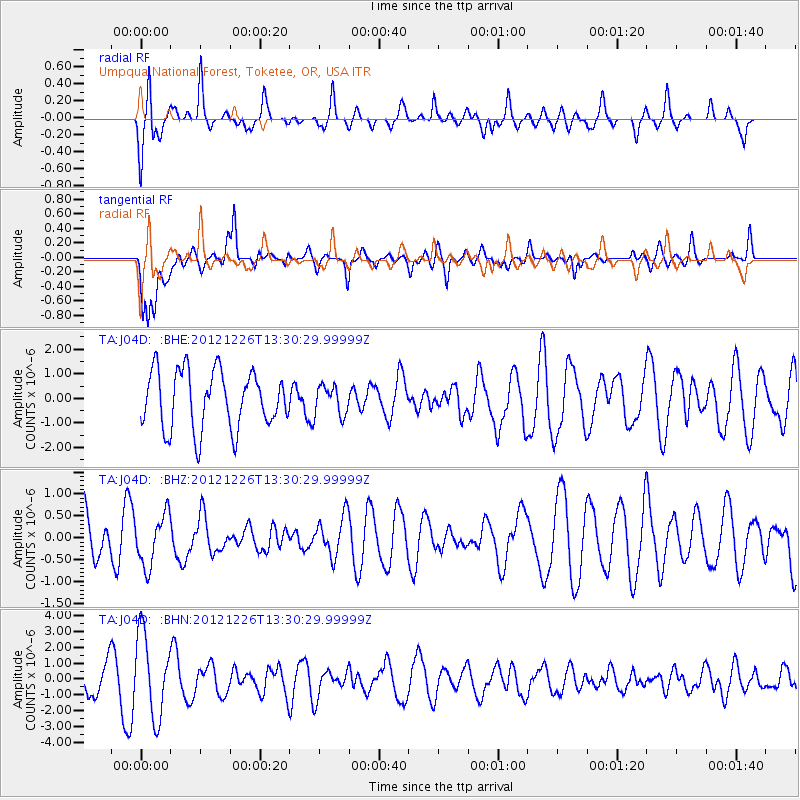
J04D Umpqua National Forest, Toketee, OR, USA - Earthquake Result Viewer
*The percent match for this event was below the threshold and hence no stack was calculated.
| Earthquake location: |
Near Coast Of Central Chile |
| Earthquake latitude/longitude: |
-37.3/-73.3 |
| Earthquake time(UTC): |
2012/12/26 (361) 13:17:57 GMT |
| Earthquake Depth: |
29 km |
| Earthquake Magnitude: |
5.5 MB, 5.2 MS, 5.2 MW, 5.4 MW |
| Earthquake Catalog/Contributor: |
WHDF/NEIC |
|
| Network: |
TA USArray Transportable Network (new EarthScope stations) |
| Station: |
J04D Umpqua National Forest, Toketee, OR, USA |
| Lat/Lon: |
43.24 N/122.11 W |
| Elevation: |
1948 m |
|
| Distance: |
91.6 deg |
| Az: |
326.604 deg |
| Baz: |
143.071 deg |
| Ray Param: |
$rayparam |
*The percent match for this event was below the threshold and hence was not used in the summary stack. |
|
| Radial Match: |
55.81751 % |
| Radial Bump: |
356 |
| Transverse Match: |
60.82343 % |
| Transverse Bump: |
400 |
| SOD ConfigId: |
491031 |
| Insert Time: |
2013-04-10 03:58:02.424 +0000 |
| GWidth: |
2.5 |
| Max Bumps: |
400 |
| Tol: |
0.001 |
|
Signal To Noise
| Channel | StoN | STA | LTA |
| TA:J04D: :BHZ:20121226T13:30:29.99999Z | 0.6111626 | 5.8281927E-7 | 9.536239E-7 |
| TA:J04D: :BHN:20121226T13:30:29.99999Z | 2.2087436 | 2.6144235E-6 | 1.18367E-6 |
| TA:J04D: :BHE:20121226T13:30:29.99999Z | 0.50270253 | 5.8943687E-7 | 1.1725361E-6 |
| Arrivals |
| Ps | |
| PpPs | |
| PsPs/PpSs | |


