You are here: Home > Network List > TA - USArray Transportable Network (new EarthScope stations) Stations List
> Station Q45A Warren Harvey, Newton, IL, USA > Earthquake Result Viewer
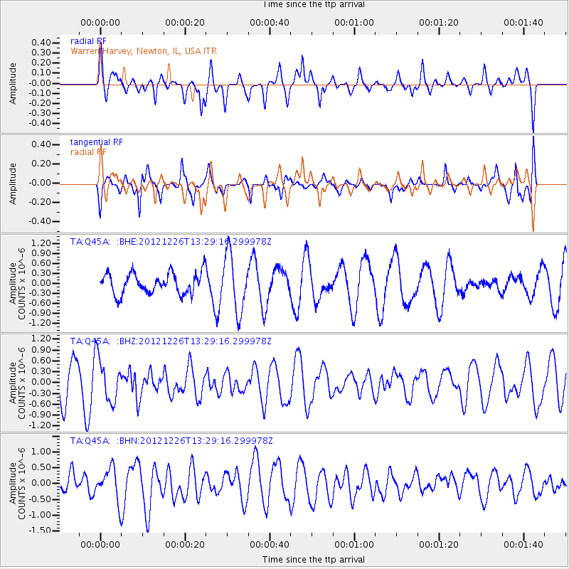
Q45A Warren Harvey, Newton, IL, USA - Earthquake Result Viewer
*The percent match for this event was below the threshold and hence no stack was calculated.
| Earthquake location: |
Near Coast Of Central Chile |
| Earthquake latitude/longitude: |
-37.3/-73.3 |
| Earthquake time(UTC): |
2012/12/26 (361) 13:17:57 GMT |
| Earthquake Depth: |
29 km |
| Earthquake Magnitude: |
5.5 MB, 5.2 MS, 5.2 MW, 5.4 MW |
| Earthquake Catalog/Contributor: |
WHDF/NEIC |
|
| Network: |
TA USArray Transportable Network (new EarthScope stations) |
| Station: |
Q45A Warren Harvey, Newton, IL, USA |
| Lat/Lon: |
38.89 N/88.16 W |
| Elevation: |
162 m |
|
| Distance: |
77.0 deg |
| Az: |
348.126 deg |
| Baz: |
167.858 deg |
| Ray Param: |
$rayparam |
*The percent match for this event was below the threshold and hence was not used in the summary stack. |
|
| Radial Match: |
62.145195 % |
| Radial Bump: |
400 |
| Transverse Match: |
55.094448 % |
| Transverse Bump: |
400 |
| SOD ConfigId: |
491031 |
| Insert Time: |
2013-04-10 03:59:41.750 +0000 |
| GWidth: |
2.5 |
| Max Bumps: |
400 |
| Tol: |
0.001 |
|
Signal To Noise
| Channel | StoN | STA | LTA |
| TA:Q45A: :BHZ:20121226T13:29:16.299978Z | 0.86399865 | 5.7607383E-7 | 6.667532E-7 |
| TA:Q45A: :BHN:20121226T13:29:16.299978Z | 1.5363218 | 5.2086745E-7 | 3.390354E-7 |
| TA:Q45A: :BHE:20121226T13:29:16.299978Z | 2.8112776 | 8.723309E-7 | 3.1029694E-7 |
| Arrivals |
| Ps | |
| PpPs | |
| PsPs/PpSs | |


