You are here: Home > Network List > TA - USArray Transportable Network (new EarthScope stations) Stations List
> Station L46A Eue Claire, MI, USA > Earthquake Result Viewer
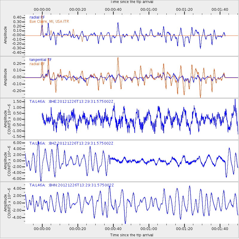
L46A Eue Claire, MI, USA - Earthquake Result Viewer
*The percent match for this event was below the threshold and hence no stack was calculated.
| Earthquake location: |
Near Coast Of Central Chile |
| Earthquake latitude/longitude: |
-37.3/-73.3 |
| Earthquake time(UTC): |
2012/12/26 (361) 13:17:57 GMT |
| Earthquake Depth: |
29 km |
| Earthquake Magnitude: |
5.5 MB, 5.2 MS, 5.2 MW, 5.4 MW |
| Earthquake Catalog/Contributor: |
WHDF/NEIC |
|
| Network: |
TA USArray Transportable Network (new EarthScope stations) |
| Station: |
L46A Eue Claire, MI, USA |
| Lat/Lon: |
42.01 N/86.30 W |
| Elevation: |
223 m |
|
| Distance: |
79.8 deg |
| Az: |
350.172 deg |
| Baz: |
169.472 deg |
| Ray Param: |
$rayparam |
*The percent match for this event was below the threshold and hence was not used in the summary stack. |
|
| Radial Match: |
48.39249 % |
| Radial Bump: |
400 |
| Transverse Match: |
39.93018 % |
| Transverse Bump: |
400 |
| SOD ConfigId: |
491031 |
| Insert Time: |
2013-04-10 04:01:12.364 +0000 |
| GWidth: |
2.5 |
| Max Bumps: |
400 |
| Tol: |
0.001 |
|
Signal To Noise
| Channel | StoN | STA | LTA |
| TA:L46A: :BHZ:20121226T13:29:31.575002Z | 2.084416 | 3.1170575E-6 | 1.4954105E-6 |
| TA:L46A: :BHN:20121226T13:29:31.575002Z | 0.584877 | 1.1633952E-6 | 1.989128E-6 |
| TA:L46A: :BHE:20121226T13:29:31.575002Z | 0.8669745 | 3.3672458E-7 | 3.8839042E-7 |
| Arrivals |
| Ps | |
| PpPs | |
| PsPs/PpSs | |


