You are here: Home > Network List > CI - Caltech Regional Seismic Network Stations List
> Station TIN Tinemaha, Big Pine, CA, USA > Earthquake Result Viewer
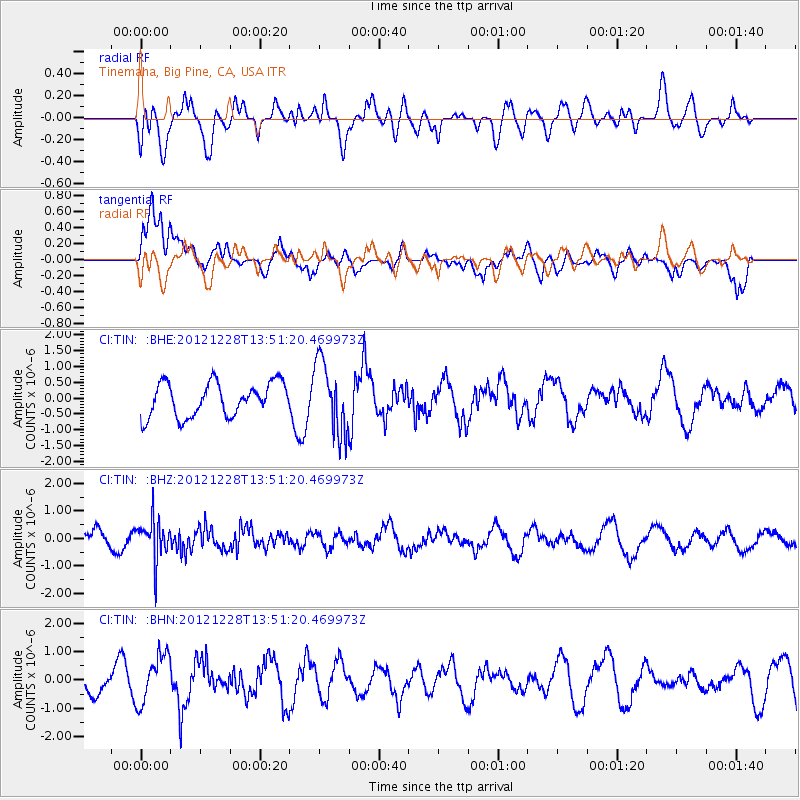
TIN Tinemaha, Big Pine, CA, USA - Earthquake Result Viewer
*The percent match for this event was below the threshold and hence no stack was calculated.
| Earthquake location: |
Komandorskiye Ostrova Region |
| Earthquake latitude/longitude: |
55.7/164.7 |
| Earthquake time(UTC): |
2012/12/28 (363) 13:42:34 GMT |
| Earthquake Depth: |
35 km |
| Earthquake Magnitude: |
5.5 MB, 5.1 MW |
| Earthquake Catalog/Contributor: |
WHDF/NEIC |
|
| Network: |
CI Caltech Regional Seismic Network |
| Station: |
TIN Tinemaha, Big Pine, CA, USA |
| Lat/Lon: |
37.05 N/118.23 W |
| Elevation: |
1197 m |
|
| Distance: |
53.4 deg |
| Az: |
76.182 deg |
| Baz: |
316.604 deg |
| Ray Param: |
$rayparam |
*The percent match for this event was below the threshold and hence was not used in the summary stack. |
|
| Radial Match: |
52.819347 % |
| Radial Bump: |
400 |
| Transverse Match: |
56.887356 % |
| Transverse Bump: |
400 |
| SOD ConfigId: |
491031 |
| Insert Time: |
2013-04-10 04:11:28.070 +0000 |
| GWidth: |
2.5 |
| Max Bumps: |
400 |
| Tol: |
0.001 |
|
Signal To Noise
| Channel | StoN | STA | LTA |
| CI:TIN: :BHZ:20121228T13:51:20.469973Z | 2.4743466 | 7.261745E-7 | 2.934813E-7 |
| CI:TIN: :BHN:20121228T13:51:20.469973Z | 1.7495749 | 8.83781E-7 | 5.0514046E-7 |
| CI:TIN: :BHE:20121228T13:51:20.469973Z | 2.1322212 | 1.1313414E-6 | 5.305929E-7 |
| Arrivals |
| Ps | |
| PpPs | |
| PsPs/PpSs | |


