You are here: Home > Network List > TA - USArray Transportable Network (new EarthScope stations) Stations List
> Station J47A Sunmer, MI, USA > Earthquake Result Viewer
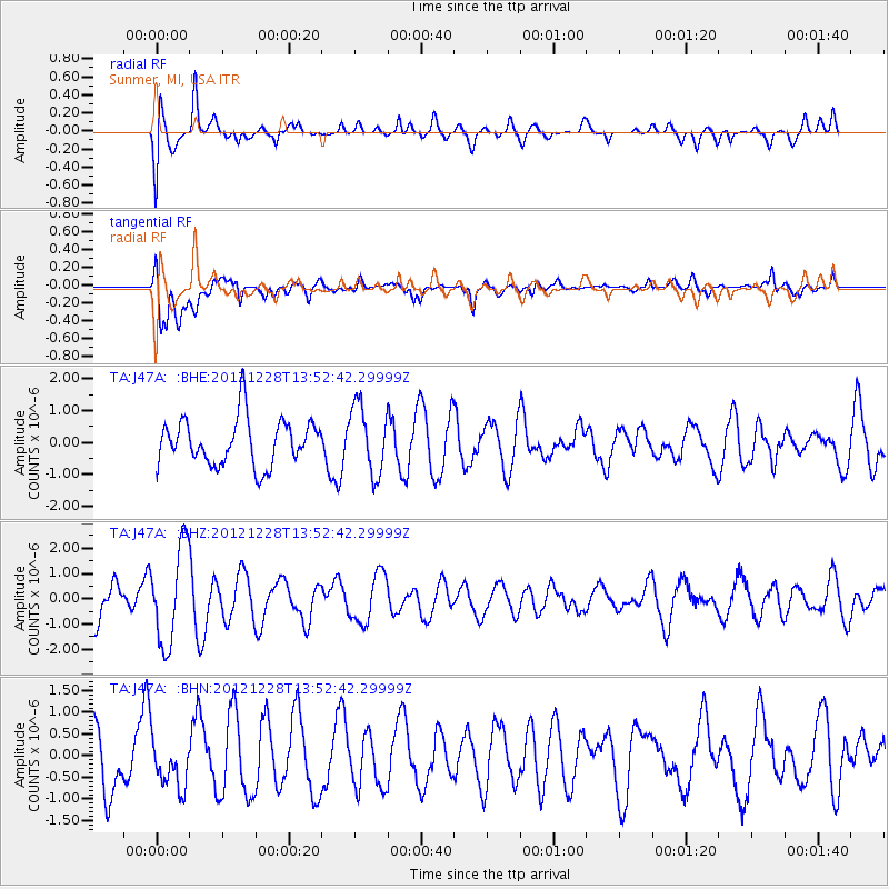
J47A Sunmer, MI, USA - Earthquake Result Viewer
*The percent match for this event was below the threshold and hence no stack was calculated.
| Earthquake location: |
Komandorskiye Ostrova Region |
| Earthquake latitude/longitude: |
55.7/164.7 |
| Earthquake time(UTC): |
2012/12/28 (363) 13:42:34 GMT |
| Earthquake Depth: |
35 km |
| Earthquake Magnitude: |
5.5 MB, 5.1 MW |
| Earthquake Catalog/Contributor: |
WHDF/NEIC |
|
| Network: |
TA USArray Transportable Network (new EarthScope stations) |
| Station: |
J47A Sunmer, MI, USA |
| Lat/Lon: |
43.24 N/84.82 W |
| Elevation: |
236 m |
|
| Distance: |
65.3 deg |
| Az: |
48.92 deg |
| Baz: |
324.28 deg |
| Ray Param: |
$rayparam |
*The percent match for this event was below the threshold and hence was not used in the summary stack. |
|
| Radial Match: |
73.739334 % |
| Radial Bump: |
400 |
| Transverse Match: |
67.37574 % |
| Transverse Bump: |
400 |
| SOD ConfigId: |
491031 |
| Insert Time: |
2013-04-10 04:19:40.413 +0000 |
| GWidth: |
2.5 |
| Max Bumps: |
400 |
| Tol: |
0.001 |
|
Signal To Noise
| Channel | StoN | STA | LTA |
| TA:J47A: :BHZ:20121228T13:52:42.29999Z | 2.3846805 | 1.9141044E-6 | 8.02667E-7 |
| TA:J47A: :BHN:20121228T13:52:42.29999Z | 0.68272 | 5.621758E-7 | 8.2343536E-7 |
| TA:J47A: :BHE:20121228T13:52:42.29999Z | 1.4410478 | 1.0542917E-6 | 7.316147E-7 |
| Arrivals |
| Ps | |
| PpPs | |
| PsPs/PpSs | |


