You are here: Home > Network List > TA - USArray Transportable Network (new EarthScope stations) Stations List
> Station J49A Marlette, MI, USA > Earthquake Result Viewer
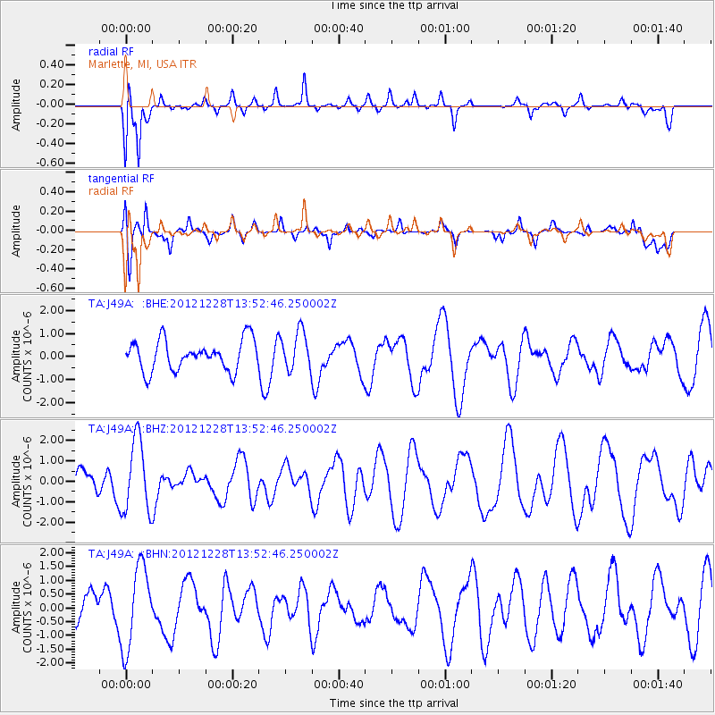
J49A Marlette, MI, USA - Earthquake Result Viewer
*The percent match for this event was below the threshold and hence no stack was calculated.
| Earthquake location: |
Komandorskiye Ostrova Region |
| Earthquake latitude/longitude: |
55.7/164.7 |
| Earthquake time(UTC): |
2012/12/28 (363) 13:42:34 GMT |
| Earthquake Depth: |
35 km |
| Earthquake Magnitude: |
5.5 MB, 5.1 MW |
| Earthquake Catalog/Contributor: |
WHDF/NEIC |
|
| Network: |
TA USArray Transportable Network (new EarthScope stations) |
| Station: |
J49A Marlette, MI, USA |
| Lat/Lon: |
43.36 N/83.14 W |
| Elevation: |
253 m |
|
| Distance: |
65.9 deg |
| Az: |
47.743 deg |
| Baz: |
324.944 deg |
| Ray Param: |
$rayparam |
*The percent match for this event was below the threshold and hence was not used in the summary stack. |
|
| Radial Match: |
80.61128 % |
| Radial Bump: |
384 |
| Transverse Match: |
60.739326 % |
| Transverse Bump: |
400 |
| SOD ConfigId: |
491031 |
| Insert Time: |
2013-04-10 04:19:54.717 +0000 |
| GWidth: |
2.5 |
| Max Bumps: |
400 |
| Tol: |
0.001 |
|
Signal To Noise
| Channel | StoN | STA | LTA |
| TA:J49A: :BHZ:20121228T13:52:46.250002Z | 2.650801 | 1.7786213E-6 | 6.7097506E-7 |
| TA:J49A: :BHN:20121228T13:52:46.250002Z | 1.6927711 | 1.5008537E-6 | 8.866253E-7 |
| TA:J49A: :BHE:20121228T13:52:46.250002Z | 1.282332 | 8.4190907E-7 | 6.5654535E-7 |
| Arrivals |
| Ps | |
| PpPs | |
| PsPs/PpSs | |


