You are here: Home > Network List > IC - New China Digital Seismograph Network Stations List
> Station LSA Tibet, China > Earthquake Result Viewer
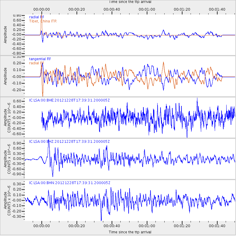
LSA Tibet, China - Earthquake Result Viewer
*The percent match for this event was below the threshold and hence no stack was calculated.
| Earthquake location: |
Minahassa Peninsula, Sulawesi |
| Earthquake latitude/longitude: |
-0.1/122.9 |
| Earthquake time(UTC): |
2012/12/28 (363) 17:32:18 GMT |
| Earthquake Depth: |
112 km |
| Earthquake Magnitude: |
5.5 MW, 5.5 MW |
| Earthquake Catalog/Contributor: |
WHDF/NEIC |
|
| Network: |
IC New China Digital Seismograph Network |
| Station: |
LSA Tibet, China |
| Lat/Lon: |
29.70 N/91.13 E |
| Elevation: |
3660 m |
|
| Distance: |
42.4 deg |
| Az: |
317.193 deg |
| Baz: |
128.644 deg |
| Ray Param: |
$rayparam |
*The percent match for this event was below the threshold and hence was not used in the summary stack. |
|
| Radial Match: |
60.770775 % |
| Radial Bump: |
400 |
| Transverse Match: |
55.388447 % |
| Transverse Bump: |
400 |
| SOD ConfigId: |
491031 |
| Insert Time: |
2013-04-10 04:23:43.821 +0000 |
| GWidth: |
2.5 |
| Max Bumps: |
400 |
| Tol: |
0.001 |
|
Signal To Noise
| Channel | StoN | STA | LTA |
| IC:LSA:00:BHZ:20121228T17:39:31.200005Z | 4.557563 | 4.0205614E-7 | 8.8217355E-8 |
| IC:LSA:00:BHN:20121228T17:39:31.200005Z | 2.4212255 | 6.869287E-8 | 2.8371117E-8 |
| IC:LSA:00:BHE:20121228T17:39:31.200005Z | 1.2086135 | 1.8957977E-7 | 1.5685723E-7 |
| Arrivals |
| Ps | |
| PpPs | |
| PsPs/PpSs | |


