You are here: Home > Network List > IC - New China Digital Seismograph Network Stations List
> Station WMQ Urumqi, Xinjiang Province, China > Earthquake Result Viewer
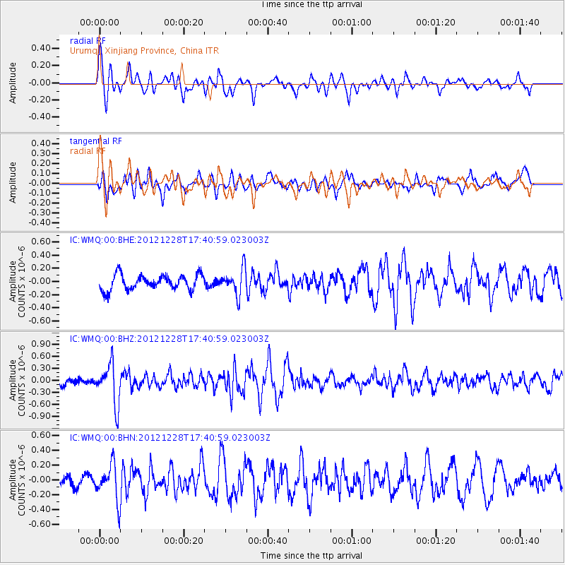
WMQ Urumqi, Xinjiang Province, China - Earthquake Result Viewer
*The percent match for this event was below the threshold and hence no stack was calculated.
| Earthquake location: |
Minahassa Peninsula, Sulawesi |
| Earthquake latitude/longitude: |
-0.1/122.9 |
| Earthquake time(UTC): |
2012/12/28 (363) 17:32:18 GMT |
| Earthquake Depth: |
112 km |
| Earthquake Magnitude: |
5.5 MW, 5.5 MW |
| Earthquake Catalog/Contributor: |
WHDF/NEIC |
|
| Network: |
IC New China Digital Seismograph Network |
| Station: |
WMQ Urumqi, Xinjiang Province, China |
| Lat/Lon: |
43.81 N/87.70 E |
| Elevation: |
850 m |
|
| Distance: |
53.9 deg |
| Az: |
328.878 deg |
| Baz: |
134.441 deg |
| Ray Param: |
$rayparam |
*The percent match for this event was below the threshold and hence was not used in the summary stack. |
|
| Radial Match: |
63.084614 % |
| Radial Bump: |
400 |
| Transverse Match: |
56.56818 % |
| Transverse Bump: |
400 |
| SOD ConfigId: |
491031 |
| Insert Time: |
2013-04-10 04:23:48.600 +0000 |
| GWidth: |
2.5 |
| Max Bumps: |
400 |
| Tol: |
0.001 |
|
Signal To Noise
| Channel | StoN | STA | LTA |
| IC:WMQ:00:BHZ:20121228T17:40:59.023003Z | 3.5416229 | 5.1842943E-7 | 1.463819E-7 |
| IC:WMQ:00:BHN:20121228T17:40:59.023003Z | 2.0962367 | 2.5438305E-7 | 1.2135226E-7 |
| IC:WMQ:00:BHE:20121228T17:40:59.023003Z | 1.8384463 | 2.1044382E-7 | 1.144683E-7 |
| Arrivals |
| Ps | |
| PpPs | |
| PsPs/PpSs | |


