You are here: Home > Network List > IU - Global Seismograph Network (GSN - IRIS/USGS) Stations List
> Station KBL Kabul, Afghanistan > Earthquake Result Viewer
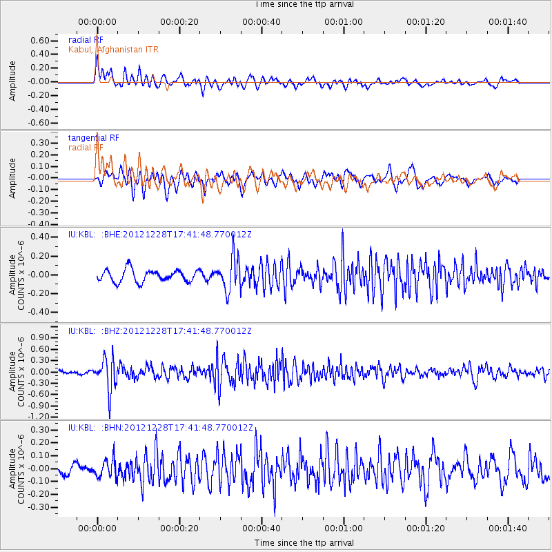
KBL Kabul, Afghanistan - Earthquake Result Viewer
*The percent match for this event was below the threshold and hence no stack was calculated.
| Earthquake location: |
Minahassa Peninsula, Sulawesi |
| Earthquake latitude/longitude: |
-0.1/122.9 |
| Earthquake time(UTC): |
2012/12/28 (363) 17:32:18 GMT |
| Earthquake Depth: |
112 km |
| Earthquake Magnitude: |
5.5 MW, 5.5 MW |
| Earthquake Catalog/Contributor: |
WHDF/NEIC |
|
| Network: |
IU Global Seismograph Network (GSN - IRIS/USGS) |
| Station: |
KBL Kabul, Afghanistan |
| Lat/Lon: |
34.54 N/69.04 E |
| Elevation: |
1920 m |
|
| Distance: |
61.0 deg |
| Az: |
310.308 deg |
| Baz: |
112.515 deg |
| Ray Param: |
$rayparam |
*The percent match for this event was below the threshold and hence was not used in the summary stack. |
|
| Radial Match: |
70.7605 % |
| Radial Bump: |
400 |
| Transverse Match: |
65.94344 % |
| Transverse Bump: |
400 |
| SOD ConfigId: |
491031 |
| Insert Time: |
2013-04-10 04:24:05.118 +0000 |
| GWidth: |
2.5 |
| Max Bumps: |
400 |
| Tol: |
0.001 |
|
Signal To Noise
| Channel | StoN | STA | LTA |
| IU:KBL: :BHZ:20121228T17:41:48.770012Z | 5.7334294 | 4.339313E-7 | 7.568442E-8 |
| IU:KBL: :BHN:20121228T17:41:48.770012Z | 1.187404 | 6.7090674E-8 | 5.6501975E-8 |
| IU:KBL: :BHE:20121228T17:41:48.770012Z | 2.8510315 | 1.8379808E-7 | 6.446722E-8 |
| Arrivals |
| Ps | |
| PpPs | |
| PsPs/PpSs | |


