You are here: Home > Network List > TA - USArray Transportable Network (new EarthScope stations) Stations List
> Station 109C Camp Elliot, Mirimar, CA, USA > Earthquake Result Viewer
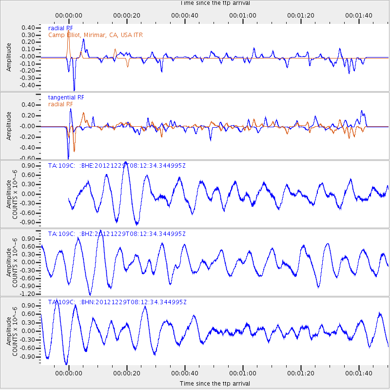
109C Camp Elliot, Mirimar, CA, USA - Earthquake Result Viewer
*The percent match for this event was below the threshold and hence no stack was calculated.
| Earthquake location: |
Bismarck Sea |
| Earthquake latitude/longitude: |
-3.6/148.9 |
| Earthquake time(UTC): |
2012/12/29 (364) 07:59:41 GMT |
| Earthquake Depth: |
4.0 km |
| Earthquake Magnitude: |
5.7 MS, 5.4 MB, 5.7 MW, 6.0 MW |
| Earthquake Catalog/Contributor: |
WHDF/NEIC |
|
| Network: |
TA USArray Transportable Network (new EarthScope stations) |
| Station: |
109C Camp Elliot, Mirimar, CA, USA |
| Lat/Lon: |
32.89 N/117.11 W |
| Elevation: |
150 m |
|
| Distance: |
95.3 deg |
| Az: |
57.448 deg |
| Baz: |
269.174 deg |
| Ray Param: |
$rayparam |
*The percent match for this event was below the threshold and hence was not used in the summary stack. |
|
| Radial Match: |
64.82771 % |
| Radial Bump: |
400 |
| Transverse Match: |
44.686127 % |
| Transverse Bump: |
400 |
| SOD ConfigId: |
491031 |
| Insert Time: |
2013-04-10 04:29:58.073 +0000 |
| GWidth: |
2.5 |
| Max Bumps: |
400 |
| Tol: |
0.001 |
|
Signal To Noise
| Channel | StoN | STA | LTA |
| TA:109C: :BHZ:20121229T08:12:34.344995Z | 1.3184524 | 6.3195716E-7 | 4.793174E-7 |
| TA:109C: :BHN:20121229T08:12:34.344995Z | 1.6037242 | 6.4601403E-7 | 4.0282112E-7 |
| TA:109C: :BHE:20121229T08:12:34.344995Z | 0.24960671 | 1.239523E-7 | 4.965904E-7 |
| Arrivals |
| Ps | |
| PpPs | |
| PsPs/PpSs | |


