You are here: Home > Network List > TA - USArray Transportable Network (new EarthScope stations) Stations List
> Station J01E Myrtle Point, OR, USA > Earthquake Result Viewer
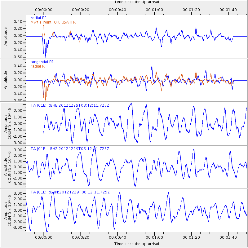
J01E Myrtle Point, OR, USA - Earthquake Result Viewer
*The percent match for this event was below the threshold and hence no stack was calculated.
| Earthquake location: |
Bismarck Sea |
| Earthquake latitude/longitude: |
-3.6/148.9 |
| Earthquake time(UTC): |
2012/12/29 (364) 07:59:41 GMT |
| Earthquake Depth: |
4.0 km |
| Earthquake Magnitude: |
5.7 MS, 5.4 MB, 5.7 MW, 6.0 MW |
| Earthquake Catalog/Contributor: |
WHDF/NEIC |
|
| Network: |
TA USArray Transportable Network (new EarthScope stations) |
| Station: |
J01E Myrtle Point, OR, USA |
| Lat/Lon: |
43.16 N/123.93 W |
| Elevation: |
128 m |
|
| Distance: |
90.3 deg |
| Az: |
46.957 deg |
| Baz: |
265.482 deg |
| Ray Param: |
$rayparam |
*The percent match for this event was below the threshold and hence was not used in the summary stack. |
|
| Radial Match: |
55.53242 % |
| Radial Bump: |
400 |
| Transverse Match: |
44.019417 % |
| Transverse Bump: |
400 |
| SOD ConfigId: |
491031 |
| Insert Time: |
2013-04-10 04:31:09.477 +0000 |
| GWidth: |
2.5 |
| Max Bumps: |
400 |
| Tol: |
0.001 |
|
Signal To Noise
| Channel | StoN | STA | LTA |
| TA:J01E: :BHZ:20121229T08:12:11.725Z | 1.9377625 | 1.244098E-6 | 6.4202817E-7 |
| TA:J01E: :BHN:20121229T08:12:11.725Z | 1.7356311 | 2.363864E-6 | 1.3619622E-6 |
| TA:J01E: :BHE:20121229T08:12:11.725Z | 0.8322795 | 1.0525473E-6 | 1.264656E-6 |
| Arrivals |
| Ps | |
| PpPs | |
| PsPs/PpSs | |


