You are here: Home > Network List > CI - Caltech Regional Seismic Network Stations List
> Station SMM Simmler, CA, USA > Earthquake Result Viewer
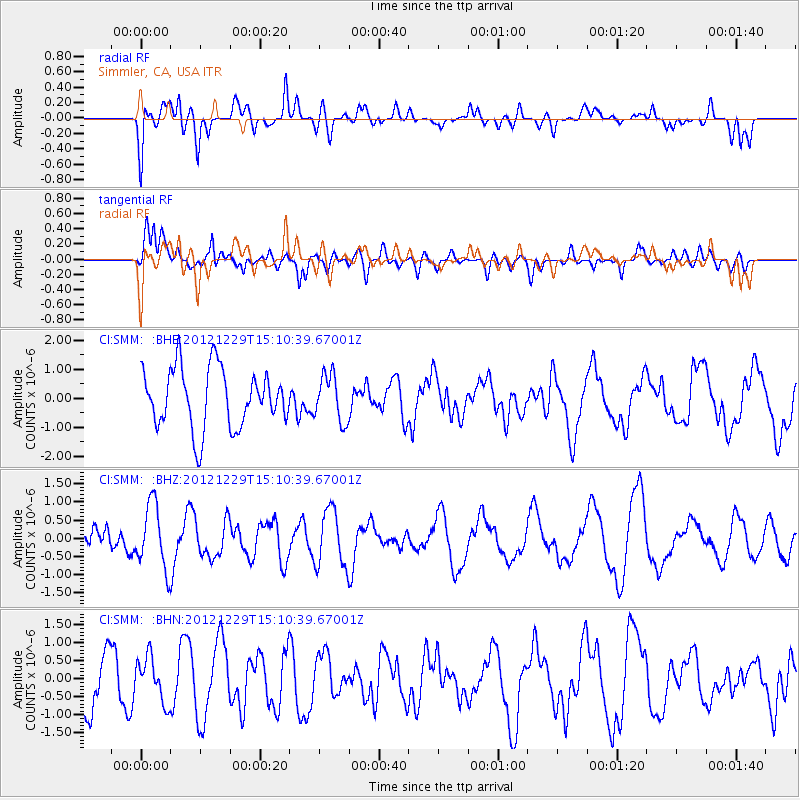
SMM Simmler, CA, USA - Earthquake Result Viewer
*The percent match for this event was below the threshold and hence no stack was calculated.
| Earthquake location: |
Near East Coast Of Honshu, Japan |
| Earthquake latitude/longitude: |
38.7/142.0 |
| Earthquake time(UTC): |
2012/12/29 (364) 14:59:38 GMT |
| Earthquake Depth: |
56 km |
| Earthquake Magnitude: |
5.5 MW, 5.4 MW, 5.4 MB |
| Earthquake Catalog/Contributor: |
WHDF/NEIC |
|
| Network: |
CI Caltech Regional Seismic Network |
| Station: |
SMM Simmler, CA, USA |
| Lat/Lon: |
35.31 N/120.00 W |
| Elevation: |
599 m |
|
| Distance: |
74.3 deg |
| Az: |
57.257 deg |
| Baz: |
306.455 deg |
| Ray Param: |
$rayparam |
*The percent match for this event was below the threshold and hence was not used in the summary stack. |
|
| Radial Match: |
49.68428 % |
| Radial Bump: |
400 |
| Transverse Match: |
62.576267 % |
| Transverse Bump: |
400 |
| SOD ConfigId: |
491031 |
| Insert Time: |
2013-04-10 04:35:01.406 +0000 |
| GWidth: |
2.5 |
| Max Bumps: |
400 |
| Tol: |
0.001 |
|
Signal To Noise
| Channel | StoN | STA | LTA |
| CI:SMM: :BHZ:20121229T15:10:39.67001Z | 2.2547848 | 8.816029E-7 | 3.9099203E-7 |
| CI:SMM: :BHN:20121229T15:10:39.67001Z | 0.89751565 | 6.230531E-7 | 6.9419747E-7 |
| CI:SMM: :BHE:20121229T15:10:39.67001Z | 0.78396297 | 8.052023E-7 | 1.0270923E-6 |
| Arrivals |
| Ps | |
| PpPs | |
| PsPs/PpSs | |


