You are here: Home > Network List > TA - USArray Transportable Network (new EarthScope stations) Stations List
> Station SFIN Lafayette, IN, USA > Earthquake Result Viewer
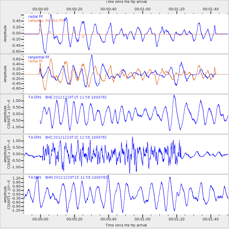
SFIN Lafayette, IN, USA - Earthquake Result Viewer
*The percent match for this event was below the threshold and hence no stack was calculated.
| Earthquake location: |
Near East Coast Of Honshu, Japan |
| Earthquake latitude/longitude: |
38.7/142.0 |
| Earthquake time(UTC): |
2012/12/29 (364) 14:59:38 GMT |
| Earthquake Depth: |
56 km |
| Earthquake Magnitude: |
5.5 MW, 5.4 MW, 5.4 MB |
| Earthquake Catalog/Contributor: |
WHDF/NEIC |
|
| Network: |
TA USArray Transportable Network (new EarthScope stations) |
| Station: |
SFIN Lafayette, IN, USA |
| Lat/Lon: |
40.38 N/87.10 W |
| Elevation: |
165 m |
|
| Distance: |
89.4 deg |
| Az: |
35.284 deg |
| Baz: |
323.747 deg |
| Ray Param: |
$rayparam |
*The percent match for this event was below the threshold and hence was not used in the summary stack. |
|
| Radial Match: |
48.047997 % |
| Radial Bump: |
400 |
| Transverse Match: |
63.629215 % |
| Transverse Bump: |
400 |
| SOD ConfigId: |
491031 |
| Insert Time: |
2013-04-10 04:38:49.218 +0000 |
| GWidth: |
2.5 |
| Max Bumps: |
400 |
| Tol: |
0.001 |
|
Signal To Noise
| Channel | StoN | STA | LTA |
| TA:SFIN: :BHZ:20121229T15:11:58.199978Z | 3.7519734 | 3.1600828E-7 | 8.422455E-8 |
| TA:SFIN: :BHN:20121229T15:11:58.199978Z | 1.2647203 | 5.466451E-7 | 4.3222605E-7 |
| TA:SFIN: :BHE:20121229T15:11:58.199978Z | 0.65334517 | 4.0377694E-7 | 6.180147E-7 |
| Arrivals |
| Ps | |
| PpPs | |
| PsPs/PpSs | |


