You are here: Home > Network List > TA - USArray Transportable Network (new EarthScope stations) Stations List
> Station J05D Fort Rock, OR, USA > Earthquake Result Viewer
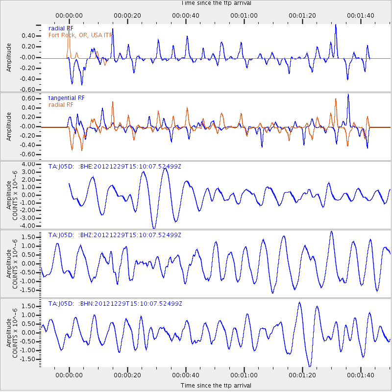
J05D Fort Rock, OR, USA - Earthquake Result Viewer
*The percent match for this event was below the threshold and hence no stack was calculated.
| Earthquake location: |
Near East Coast Of Honshu, Japan |
| Earthquake latitude/longitude: |
38.7/142.0 |
| Earthquake time(UTC): |
2012/12/29 (364) 14:59:38 GMT |
| Earthquake Depth: |
56 km |
| Earthquake Magnitude: |
5.5 MW, 5.4 MW, 5.4 MB |
| Earthquake Catalog/Contributor: |
WHDF/NEIC |
|
| Network: |
TA USArray Transportable Network (new EarthScope stations) |
| Station: |
J05D Fort Rock, OR, USA |
| Lat/Lon: |
43.28 N/121.23 W |
| Elevation: |
1541 m |
|
| Distance: |
69.0 deg |
| Az: |
50.978 deg |
| Baz: |
303.692 deg |
| Ray Param: |
$rayparam |
*The percent match for this event was below the threshold and hence was not used in the summary stack. |
|
| Radial Match: |
56.679913 % |
| Radial Bump: |
383 |
| Transverse Match: |
58.974617 % |
| Transverse Bump: |
351 |
| SOD ConfigId: |
491031 |
| Insert Time: |
2013-04-10 04:38:58.621 +0000 |
| GWidth: |
2.5 |
| Max Bumps: |
400 |
| Tol: |
0.001 |
|
Signal To Noise
| Channel | StoN | STA | LTA |
| TA:J05D: :BHZ:20121229T15:10:07.52499Z | 1.4455572 | 6.709092E-7 | 4.6411802E-7 |
| TA:J05D: :BHN:20121229T15:10:07.52499Z | 0.5019757 | 4.6424324E-7 | 9.24832E-7 |
| TA:J05D: :BHE:20121229T15:10:07.52499Z | 2.283664 | 2.8200725E-6 | 1.2348895E-6 |
| Arrivals |
| Ps | |
| PpPs | |
| PsPs/PpSs | |


