You are here: Home > Network List > TA - USArray Transportable Network (new EarthScope stations) Stations List
> Station G03D McMinnville, OR, USA > Earthquake Result Viewer
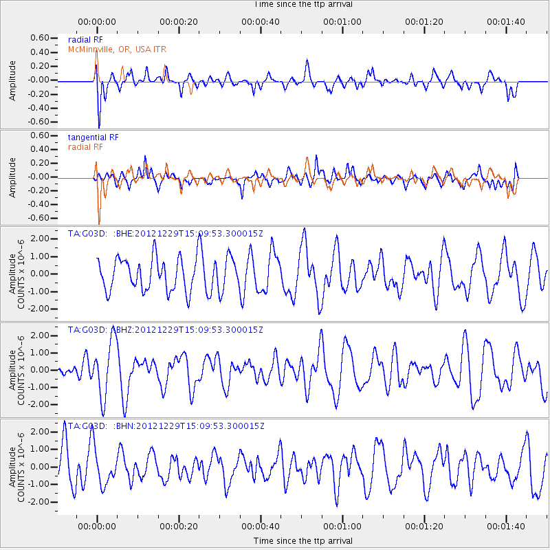
G03D McMinnville, OR, USA - Earthquake Result Viewer
*The percent match for this event was below the threshold and hence no stack was calculated.
| Earthquake location: |
Near East Coast Of Honshu, Japan |
| Earthquake latitude/longitude: |
38.7/142.0 |
| Earthquake time(UTC): |
2012/12/29 (364) 14:59:38 GMT |
| Earthquake Depth: |
56 km |
| Earthquake Magnitude: |
5.5 MW, 5.4 MW, 5.4 MB |
| Earthquake Catalog/Contributor: |
WHDF/NEIC |
|
| Network: |
TA USArray Transportable Network (new EarthScope stations) |
| Station: |
G03D McMinnville, OR, USA |
| Lat/Lon: |
45.21 N/123.26 W |
| Elevation: |
222 m |
|
| Distance: |
66.7 deg |
| Az: |
50.084 deg |
| Baz: |
301.943 deg |
| Ray Param: |
$rayparam |
*The percent match for this event was below the threshold and hence was not used in the summary stack. |
|
| Radial Match: |
52.643917 % |
| Radial Bump: |
400 |
| Transverse Match: |
69.84118 % |
| Transverse Bump: |
400 |
| SOD ConfigId: |
491031 |
| Insert Time: |
2013-04-10 04:39:01.849 +0000 |
| GWidth: |
2.5 |
| Max Bumps: |
400 |
| Tol: |
0.001 |
|
Signal To Noise
| Channel | StoN | STA | LTA |
| TA:G03D: :BHZ:20121229T15:09:53.300015Z | 1.8054378 | 1.6670501E-6 | 9.233495E-7 |
| TA:G03D: :BHN:20121229T15:09:53.300015Z | 0.8642077 | 9.511116E-7 | 1.1005591E-6 |
| TA:G03D: :BHE:20121229T15:09:53.300015Z | 1.0359515 | 9.4915254E-7 | 9.1621325E-7 |
| Arrivals |
| Ps | |
| PpPs | |
| PsPs/PpSs | |


