You are here: Home > Network List > TA - USArray Transportable Network (new EarthScope stations) Stations List
> Station N59A State Game Land 141, Hazleton, PA, USA > Earthquake Result Viewer
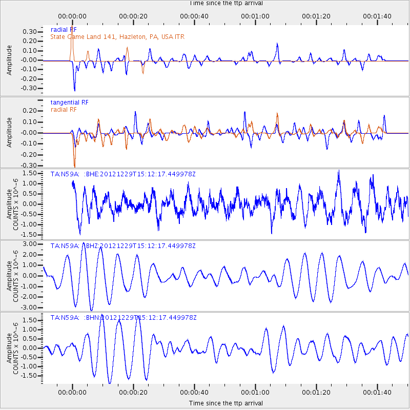
N59A State Game Land 141, Hazleton, PA, USA - Earthquake Result Viewer
*The percent match for this event was below the threshold and hence no stack was calculated.
| Earthquake location: |
Near East Coast Of Honshu, Japan |
| Earthquake latitude/longitude: |
38.7/142.0 |
| Earthquake time(UTC): |
2012/12/29 (364) 14:59:38 GMT |
| Earthquake Depth: |
56 km |
| Earthquake Magnitude: |
5.5 MW, 5.4 MW, 5.4 MB |
| Earthquake Catalog/Contributor: |
WHDF/NEIC |
|
| Network: |
TA USArray Transportable Network (new EarthScope stations) |
| Station: |
N59A State Game Land 141, Hazleton, PA, USA |
| Lat/Lon: |
40.92 N/75.77 W |
| Elevation: |
508 m |
|
| Distance: |
93.5 deg |
| Az: |
27.73 deg |
| Baz: |
331.302 deg |
| Ray Param: |
$rayparam |
*The percent match for this event was below the threshold and hence was not used in the summary stack. |
|
| Radial Match: |
49.390743 % |
| Radial Bump: |
380 |
| Transverse Match: |
59.57708 % |
| Transverse Bump: |
400 |
| SOD ConfigId: |
491031 |
| Insert Time: |
2013-04-10 04:39:21.980 +0000 |
| GWidth: |
2.5 |
| Max Bumps: |
400 |
| Tol: |
0.001 |
|
Signal To Noise
| Channel | StoN | STA | LTA |
| TA:N59A: :BHZ:20121229T15:12:17.449978Z | 3.5660844 | 2.0227794E-6 | 5.6722706E-7 |
| TA:N59A: :BHN:20121229T15:12:17.449978Z | 1.2012354 | 4.0903637E-7 | 3.4051308E-7 |
| TA:N59A: :BHE:20121229T15:12:17.449978Z | 0.75406426 | 3.5344613E-7 | 4.6872145E-7 |
| Arrivals |
| Ps | |
| PpPs | |
| PsPs/PpSs | |


