You are here: Home > Network List > TA - USArray Transportable Network (new EarthScope stations) Stations List
> Station S52A Salyersville, KY, USA > Earthquake Result Viewer
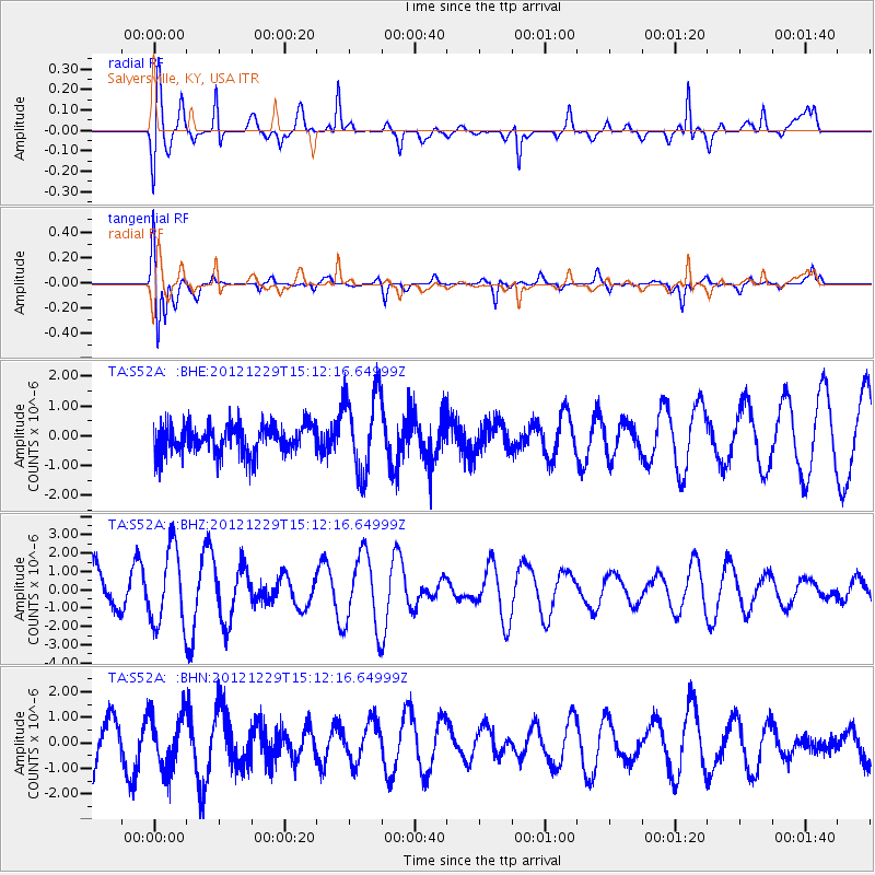
S52A Salyersville, KY, USA - Earthquake Result Viewer
*The percent match for this event was below the threshold and hence no stack was calculated.
| Earthquake location: |
Near East Coast Of Honshu, Japan |
| Earthquake latitude/longitude: |
38.7/142.0 |
| Earthquake time(UTC): |
2012/12/29 (364) 14:59:38 GMT |
| Earthquake Depth: |
56 km |
| Earthquake Magnitude: |
5.5 MW, 5.4 MW, 5.4 MB |
| Earthquake Catalog/Contributor: |
WHDF/NEIC |
|
| Network: |
TA USArray Transportable Network (new EarthScope stations) |
| Station: |
S52A Salyersville, KY, USA |
| Lat/Lon: |
37.68 N/83.08 W |
| Elevation: |
367 m |
|
| Distance: |
93.4 deg |
| Az: |
34.264 deg |
| Baz: |
326.293 deg |
| Ray Param: |
$rayparam |
*The percent match for this event was below the threshold and hence was not used in the summary stack. |
|
| Radial Match: |
72.40016 % |
| Radial Bump: |
400 |
| Transverse Match: |
83.36544 % |
| Transverse Bump: |
400 |
| SOD ConfigId: |
491031 |
| Insert Time: |
2013-04-10 04:42:10.549 +0000 |
| GWidth: |
2.5 |
| Max Bumps: |
400 |
| Tol: |
0.001 |
|
Signal To Noise
| Channel | StoN | STA | LTA |
| TA:S52A: :BHZ:20121229T15:12:16.64999Z | 1.9772351 | 2.0848763E-6 | 1.0544403E-6 |
| TA:S52A: :BHN:20121229T15:12:16.64999Z | 1.1394564 | 1.0566924E-6 | 9.273654E-7 |
| TA:S52A: :BHE:20121229T15:12:16.64999Z | 2.7966204 | 1.3540318E-6 | 4.841672E-7 |
| Arrivals |
| Ps | |
| PpPs | |
| PsPs/PpSs | |


