You are here: Home > Network List > TA - USArray Transportable Network (new EarthScope stations) Stations List
> Station 121A Cookes Peak, Deming, NM, USA > Earthquake Result Viewer
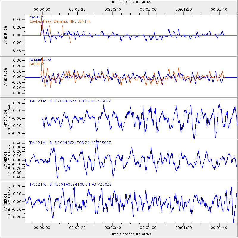
121A Cookes Peak, Deming, NM, USA - Earthquake Result Viewer
*The percent match for this event was below the threshold and hence no stack was calculated.
| Earthquake location: |
Rat Islands, Aleutian Islands |
| Earthquake latitude/longitude: |
52.2/176.6 |
| Earthquake time(UTC): |
2014/06/24 (175) 08:12:33 GMT |
| Earthquake Depth: |
23 km |
| Earthquake Magnitude: |
5.8 MW |
| Earthquake Catalog/Contributor: |
ISC/ISC |
|
| Network: |
TA USArray Transportable Network (new EarthScope stations) |
| Station: |
121A Cookes Peak, Deming, NM, USA |
| Lat/Lon: |
32.53 N/107.79 W |
| Elevation: |
1652 m |
|
| Distance: |
56.6 deg |
| Az: |
78.636 deg |
| Baz: |
314.391 deg |
| Ray Param: |
$rayparam |
*The percent match for this event was below the threshold and hence was not used in the summary stack. |
|
| Radial Match: |
71.31808 % |
| Radial Bump: |
400 |
| Transverse Match: |
45.723408 % |
| Transverse Bump: |
400 |
| SOD ConfigId: |
3390531 |
| Insert Time: |
2019-04-12 12:44:15.950 +0000 |
| GWidth: |
2.5 |
| Max Bumps: |
400 |
| Tol: |
0.001 |
|
Signal To Noise
| Channel | StoN | STA | LTA |
| TA:121A: :BHZ:20140624T08:21:43.72502Z | 0.5939721 | 5.4284484E-8 | 9.1392316E-8 |
| TA:121A: :BHN:20140624T08:21:43.72502Z | 1.1159085 | 5.7847107E-8 | 5.1838573E-8 |
| TA:121A: :BHE:20140624T08:21:43.72502Z | 1.8167568 | 8.790771E-8 | 4.838716E-8 |
| Arrivals |
| Ps | |
| PpPs | |
| PsPs/PpSs | |


